|
search place name
|
||
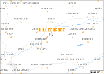
Ville-du-Pont (Franche-Comté, France)Ville-du-Pont is a town in the Franche-Comté region of France. An overview map of the region around Ville-du-Pont is displayed below.
regional and 3d topo map of Ville-du-Pont, France ::
Ville-du-Pont airports ::
The nearest airport is BRN - Bern Belp, located 77.8 km east of Ville-du-Pont.
Other airports nearby include DLE - Dole Tavaux (80.4 km west), GVA - Geneva Cointrin (89.4 km south), QNJ - Annemasse (91.3 km south), MLH - Bale Mulhouse (102.8 km north east), Nearby towns ::
La Longeville (1.3km west) //
Montbenoît (2.2km south west) //
Montflovin (3.1km south west) //
Hauterive-la-Fresse (4.5km south west) //
Gilley (5.6km north) //
La Chaux (4.2km north west) //
Les Alliés (6.1km south west) //
Lièvremont (5.3km south west) //
Les Gras (5.1km east) //
Maisons du Bois (6.3km south west) //
Hüttenberg (8.3km south east) //
Les Combes (9.0km north east) //
[all distances 'as the bird flies' and approximate] 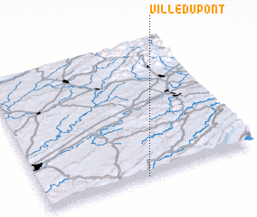 Places with similar names to Ville-du-Pont, France ::
// Vale da Pinta (PT)
// Vila da Ponte (PT)
// Vila da Ponte (PT)
// Flat Point (JM)
// Valão do Ponto (BR)
Disclaimer :: Information on this page comes without warranty of any kind |
||
|
Where is Ville-du-Pont? Elevation and coordinates ::
Latitude (lat): 47°0'0"N Longitude (lon): 6°29'0"E
Elevation (approx.): 860m (map arrows pan, magnifying glasses zoom) |
||
|
Visiting Ville-du-Pont? Hotel/Accommodation ::
Book a hotel in Ville-du-Pont Travel Guide ::
Buy a travel guide for France rental cars ::
car rental offers GPS waypoint ::
download a GPX waypoint (PoI) of Ville-du-Pont for your GPS receiver
|
||