|
search place name
|
||
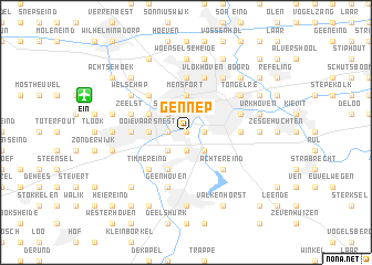
Gennep (Noord-Brabant, Netherlands)Gennep is a town in the Noord-Brabant region of Netherlands. An overview map of the region around Gennep is displayed below.
regional and 3d topo map of Gennep, Netherlands ::
Gennep airports ::
The nearest airport is EIN - Eindhoven, located 7.4 km north west of Gennep.
Other airports nearby include MST - Maastricht (60.1 km south), GKE - Geilenkirchen (64.7 km south east), ANR - Antwerp Deurne (74.6 km west), MGL - Moenchengladbach Monchengladbach (75.3 km east), Nearby towns ::
Gestel (0.0km north) //
Stratum (1.2km east) //
Blaarthem (1.2km west) //
Voldijn (1.9km south) //
Strijp (2.2km north west) //
Aalst (2.2km south east) //
Ekenrooi (2.2km south east) //
Het Broek (2.2km south west) //
Eindhoven (3.7km north) //
Mensfort (3.7km north) //
Ooievaarsnest (2.3km west) //
Biezenkuilen (3.0km north west) //
ʼt Ven (3.0km north west) //
Waalre (3.9km south) //
Loon (3.9km south) //
Heikant (3.9km south) //
Lievendaal (4.4km north west) //
Achtereind (4.4km south east) //
De Heuvel (4.4km south west) //
Timmereind (4.4km south west) //
Jagershoef (5.6km north) //
Prinsejacht (5.6km north) //
Tivoli (3.5km east) //
Meerveldhoven (3.5km west) //
Dʼ Ekker (3.5km west) //
Veldhoven (3.5km west) //
Riel (3.5km east) //
Vlokhoven (5.7km north) //
Putten (3.9km north east) //
[all distances 'as the bird flies' and approximate]  Places with similar names to Gennep, Netherlands ::
Disclaimer :: Information on this page comes without warranty of any kind |
||
|
Where is Gennep? Elevation and coordinates ::
Latitude (lat): 51°25'0"N Longitude (lon): 5°28'0"E
Elevation (approx.): 17m (map arrows pan, magnifying glasses zoom) |
||
|
Visiting Gennep? Hotel/Accommodation ::
Book a hotel in Gennep Travel Guide ::
Buy a travel guide for Netherlands rental cars ::
car rental offers GPS waypoint ::
download a GPX waypoint (PoI) of Gennep for your GPS receiver
|
||