|
search place name
|
||
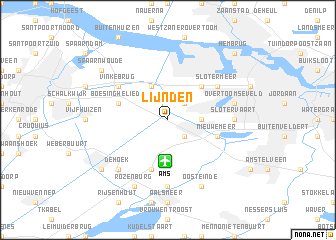
Lijnden (Noord-Holland, Netherlands)Lijnden is a town in the Noord-Holland region of Netherlands. An overview map of the region around Lijnden is displayed below.
regional and 3d topo map of Lijnden, Netherlands ::
nearby GPS traces from timatio ::
Lijnden airports ::
The nearest airport is AMS - Amsterdam Schiphol, located 4.6 km south of Lijnden.
Other airports nearby include LID - Valkenburg (31.4 km south west), UTC - Soesterberg (42.7 km south east), RTM - Rotterdam (49.2 km south west), DHR - De Kooy (63.8 km north), Nearby towns ::
Osdorp (2.2km north east) //
Badhoevedorp (2.2km south east) //
Sloten (2.3km east) //
Zwanenburg (3.9km north) //
Halfweg (3.9km north) //
Geuzenveld (4.3km north east) //
Boesingheliede (3.9km north west) //
Nieuwe Meer (3.9km south east) //
Schiphol (5.7km south) //
Vinkebrug (5.0km north west) //
Slotermeer (5.0km north east) //
Slotervaart (4.5km east) //
Oude Meer (7.4km south) //
Overtoomseveld (4.9km east) //
De Hoek (6.5km south west) //
Oosteinde (7.8km south) //
Rozenburg (7.8km south) //
Spaarnwoude (7.2km north west) //
Hoofddorp (7.2km south west) //
Hembrug (8.7km north east) //
[all distances 'as the bird flies' and approximate]  Places with similar names to Lijnden, Netherlands ::
// Lijnden (NL)
Disclaimer :: Information on this page comes without warranty of any kind |
||
|
Where is Lijnden? Elevation and coordinates ::
Latitude (lat): 52°21'0"N Longitude (lon): 4°46'0"E
Elevation (approx.): -4m (map arrows pan, magnifying glasses zoom) |
||
|
Visiting Lijnden? Hotel/Accommodation ::
Book a hotel in Lijnden Travel Guide ::
Buy a travel guide for Netherlands rental cars ::
car rental offers GPS waypoint ::
download a GPX waypoint (PoI) of Lijnden for your GPS receiver
|
||