|
search place name
|
||
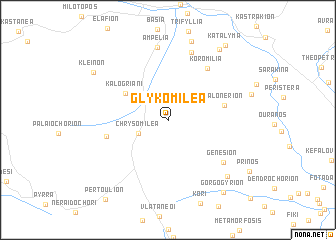
Glykomiléa (Tríkala, Greece)Glykomiléa is a town in the Tríkala region of Greece. An overview map of the region around Glykomiléa is displayed below.
regional and 3d topo map of Glykomiléa, Greece ::
Glykomiléa airports ::
The nearest airport is IOA - Ioannina, located 61.2 km west of Glykomiléa.
Other airports nearby include KZI - Kozani Filippos (78.5 km north), LRA - Larissa Larisa (80.4 km east), KSO - Kastoria Aristotelis (94.0 km north), PVK - Preveza Aktio (101.6 km south west), Nearby towns ::
Chrysomiléa (2.9km south west) //
Kalogrianí (4.7km north west) //
Kalonérion (5.1km east) //
Aïdón (5.6km west) //
Koromiliá (6.7km north east) //
Genésion (6.8km south east) //
Krýa Vrýsi (7.8km north) //
Ampélia (8.1km north) //
Pandocheía (8.9km north) //
Pródromos (8.2km south east) //
Diáva (9.0km north east) //
Kleinón (8.3km north west) //
Gorgogýrion (9.4km south east) //
Katályma (9.7km north east) //
Pertoúlion (10.4km south west) //
[all distances 'as the bird flies' and approximate]  Places with similar names to Glykomiléa, Greece ::
// Gałki Małe (PL)
// Gałków Mały (PL)
// Kołaki Małe (PL)
// Galića Mala (BA)
// Click Mill (US)
// Kalugumalai (IN)
// Galagammulla (LK)
// Kalū Kamālī (IR)
// Kāla Kamāla (PK)
// Colića Mala (CS)
Disclaimer :: Information on this page comes without warranty of any kind |
||
|
Where is Glykomiléa? Elevation and coordinates ::
Latitude (lat): 39°37'17"N Longitude (lon): 21°31'45"E
Elevation (approx.): 631m (map arrows pan, magnifying glasses zoom) |
||
|
Visiting Glykomiléa? Hotel/Accommodation ::
Book a hotel in Glykomiléa Travel Guide ::
Buy a travel guide for Greece rental cars ::
car rental offers GPS waypoint ::
download a GPX waypoint (PoI) of Glykomiléa for your GPS receiver
|
||