|
search place name
|
||
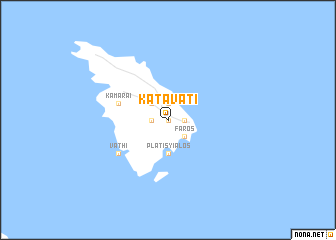
Katavatí (Piraiévs, Greece)Katavatí is a town in the Piraiévs region of Greece. An overview map of the region around Katavatí is displayed below.
regional and 3d topo map of Katavatí, Greece ::
Katavatí airports ::
The nearest airport is JMK - Mykonos Mikonos, located 75.4 km north east of Katavatí.
Other airports nearby include JTR - Santorini (91.7 km south east), CHQ - Chania Souda (167.6 km south), KIT - Kithira (171.7 km south west), HER - Heraklion Nikos Kazantzakis (185.0 km south), Nearby towns ::
Exámbela (0.0km north) //
Apollonía (1.5km west) //
Khersónisos (1.9km north) //
Áno Petálion (1.9km north) //
Kástron (1.5km east) //
Artemón (2.4km north west) //
Káto Petálion (2.4km north west) //
Fáros (2.4km south east) //
Platís Yialós (3.7km south) //
Kamárai (4.8km north west) //
Áyioi Anáryiroi (4.8km north west) //
Vathí (5.8km south west) //
[all distances 'as the bird flies' and approximate]  Places with similar names to Katavatí, Greece ::
// Cadavedo (ES)
// Gādighāt (BD)
// Gaidghāt (BD)
// Guatavita (CO)
// Gudivāda (IN)
// Kot Fateh (IN)
// Kottavattai (LK)
// Kādāvūd (IR)
// Kot Fattu (PK)
// Kot Ghatta (PK)
Disclaimer :: Information on this page comes without warranty of any kind |
||
|
Where is Katavatí? Elevation and coordinates ::
Latitude (lat): 36°58'0"N Longitude (lon): 24°44'0"E
Elevation (approx.): 150m (map arrows pan, magnifying glasses zoom) |
||
|
Visiting Katavatí? Hotel/Accommodation ::
Book a hotel in Katavatí Travel Guide ::
Buy a travel guide for Greece rental cars ::
car rental offers GPS waypoint ::
download a GPX waypoint (PoI) of Katavatí for your GPS receiver
|
||