|
search place name
|
||
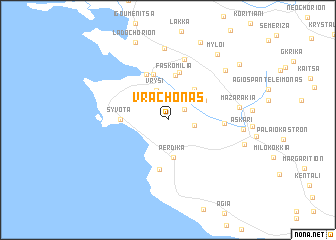
Vrachonás (Thesprotía, Greece)Vrachonás is a town in the Thesprotía region of Greece. An overview map of the region around Vrachonás is displayed below.
regional and 3d topo map of Vrachonás, Greece ::
Vrachonás airports ::
The nearest airport is CFU - Kerkyra/corfu Ioannis Kapodistrias Intl, located 39.7 km north west of Vrachonás.
Other airports nearby include IOA - Ioannina (55.4 km north east), PVK - Preveza Aktio (67.0 km south east), AGQ - Agrinion (127.7 km south east), KSO - Kastoria Aristotelis (142.8 km north east), Nearby towns ::
Argyrótopos (1.8km north east) //
Polynérion (2.4km east) //
Vrýsi (3.4km north) //
Pérdika (4.2km south) //
Skorpióna (4.1km north east) //
Kódra (3.9km north east) //
Faskomiliá (5.0km north) //
Sývota (4.1km west) //
Vrésta (5.3km north) //
Zoumpátsi (5.4km north) //
Aríllas (5.5km south) //
Platariá (5.4km north) //
Pánaina (4.9km east) //
Agía Marína (6.9km north) //
Graikochórion (8.0km north) //
Mazarakiá (6.3km east) //
Makrochóra (7.4km north east) //
Askári (6.6km east) //
Kartérion (7.1km east) //
Mýloi (8.4km north east) //
Kryóvrysi (9.1km north) //
Ladochórion (9.1km north) //
Nounesátion (8.7km north east) //
[all distances 'as the bird flies' and approximate]  Places with similar names to Vrachonás, Greece ::
// Fairchance (US)
// Fairchance (US)
Disclaimer :: Information on this page comes without warranty of any kind |
||
|
Where is Vrachonás? Elevation and coordinates ::
Latitude (lat): 39°24'24"N Longitude (lon): 20°17'53"E
Elevation (approx.): 533m (map arrows pan, magnifying glasses zoom) |
||
|
Visiting Vrachonás? Hotel/Accommodation ::
Book a hotel in Vrachonás Travel Guide ::
Buy a travel guide for Greece rental cars ::
car rental offers GPS waypoint ::
download a GPX waypoint (PoI) of Vrachonás for your GPS receiver
|
||