|
search place name
|
||
Agras (Aveiro, Portugal)Agras is a town in the Aveiro region of Portugal. An overview map of the region around Agras is displayed below.
regional and 3d topo map of Agras, Portugal ::

Agras airports ::
The nearest airport is OPO - Porto, located 43.8 km north west of Agras.
Other airports nearby include VRL - Vila Real (66.2 km north east), VGO - Vigo (145.8 km north), BGC - Braganca (172.6 km north east), SCQ - Santiago (218.1 km north), Nearby towns ::
Estrada (0.0km north) //
Mansores (0.0km north) //
Vila (0.0km north) //
Soutelo (1.9km south) //
Mato (1.4km east) //
Vila Chã (2.3km north west) //
Abitureira (2.3km north east) //
Vale de Lameiro (2.8km west) //
Gestosa (2.8km west) //
Borralhoso (3.7km north) //
Póvoa (2.8km east) //
Penaceira (2.8km east) //
Carvalhal (2.8km east) //
Ver (3.4km north west) //
Farrapa (4.0km south) //
Chave (4.0km south) //
Mosteirô (4.0km north) //
Coval Quente (4.0km north) //
Carvalhal Redondo (4.0km north) //
Belece (4.6km north west) //
Folgosinho (4.6km north east) //
Lázaro (5.6km north) //
Tropeço (4.2km east) //
Escariz (4.2km west) //
Figueiredo (4.2km west) //
Alvito de Baixo (4.2km west) //
Baloca (5.7km north) //
Paço (4.6km south east) //
Fajões (4.6km south west) //
[all distances 'as the bird flies' and approximate] 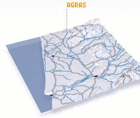 Places with similar names to Agras, Portugal ::
Disclaimer :: Information on this page comes without warranty of any kind |
||
|
Where is Agras? Elevation and coordinates ::
Latitude (lat): 40°56'0"N Longitude (lon): 8°22'0"W
Elevation (approx.): 365m (map arrows pan, magnifying glasses zoom) |
||
|
Visiting Agras? Hotel/Accommodation ::
Book a hotel in Agras Travel Guide ::
Buy a travel guide for Portugal rental cars ::
car rental offers GPS waypoint ::
download a GPX waypoint (PoI) of Agras for your GPS receiver
|
||