|
search place name
|
||
Barra (Aveiro, Portugal)Barra is a town in the Aveiro region of Portugal. An overview map of the region around Barra is displayed below.
regional and 3d topo map of Barra, Portugal ::

Barra airports ::
The nearest airport is OPO - Porto, located 68.5 km north of Barra.
Other airports nearby include VRL - Vila Real (112.2 km north east), VGO - Vigo (177.8 km north), LIS - Lisbon Lisboa (208.3 km south), BJZ - Badajoz Talavera La Real (254.4 km south east), Nearby towns ::
Costa Nova (1.9km south) //
Paredão (1.4km east) //
Marinha Velha (1.4km east) //
Laguinho (1.4km east) //
Gafanha da Encarnação (2.3km south east) //
Gafanha da Nazaré (2.8km east) //
Bebedouro (2.8km east) //
Cambeia (2.8km east) //
Palheiros de São Jacinto (3.7km north) //
São Jacinto (4.0km north) //
Cale da Vila (4.2km east) //
Gafanha do Carmo (5.7km south) //
Chave (4.6km north east) //
Gafanha da Vagueira (7.4km south) //
Chousa Velha (6.7km south east) //
Gafanha Daquém (6.7km south east) //
Vista Alegre (7.9km south east) //
Ermida (7.9km south east) //
[all distances 'as the bird flies' and approximate] 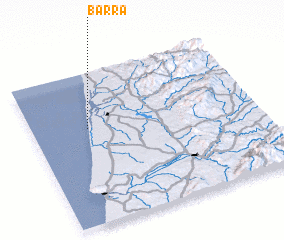 Places with similar names to Barra, Portugal ::
Disclaimer :: Information on this page comes without warranty of any kind |
||
|
Where is Barra? Elevation and coordinates ::
Latitude (lat): 40°38'0"N Longitude (lon): 8°45'0"W
Elevation (approx.): -32768m (map arrows pan, magnifying glasses zoom) |
||
|
Visiting Barra? Hotel/Accommodation ::
Book a hotel in Barra Travel Guide ::
Buy a travel guide for Portugal rental cars ::
car rental offers GPS waypoint ::
download a GPX waypoint (PoI) of Barra for your GPS receiver
|
||