|
search place name
|
||
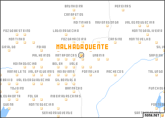
Malhada Quente (Faro, Portugal)Malhada Quente is a town in the Faro region of Portugal. An overview map of the region around Malhada Quente is displayed below.
regional and 3d topo map of Malhada Quente, Portugal ::
Malhada Quente airports ::
The nearest airport is FAO - Faro, located 61.6 km south east of Malhada Quente.
Other airports nearby include LIS - Lisbon Lisboa (169.2 km north), BJZ - Badajoz Talavera La Real (229.0 km north east), Nearby towns ::
Cabeços (NaNkm north) //
Cabeça de Águia (NaNkm north) //
Melão (NaNkm north) //
Montinhos da Serra (1.9km south) //
Serra (1.9km south) //
Bemposta (1.9km south) //
Brejo (1.9km south) //
Seixal (1.5km west) //
Casa Velha (2.4km south east) //
Vale (2.4km south west) //
Monchique (2.4km south west) //
Pé da Cruz (2.4km south west) //
Pomba (2.4km north east) //
Umbria (2.9km east) //
Portela das Eiras (2.9km west) //
Alcaria do Peso (2.9km west) //
Mata Porcas (2.9km west) //
Peso (2.9km west) //
Cimalhas (3.7km north) //
Fornalha (4.0km south) //
Barranco do Banho (4.0km south) //
Pomar Velho (3.5km south west) //
Foz da Maceira (4.0km north) //
Corte Pereiro (4.7km south west) //
Coroadinhas (4.7km south west) //
Nave (4.7km south west) //
Meia Viana (4.7km south west) //
Carvalho de Cima (4.7km north east) //
Pedras Juntas (4.4km west) //
[all distances 'as the bird flies' and approximate]  Places with similar names to Malhada Quente, Portugal :: Disclaimer :: Information on this page comes without warranty of any kind |
||
|
Where is Malhada Quente? Elevation and coordinates ::
Latitude (lat): 37°20'0"N Longitude (lon): 8°32'0"W
Elevation (approx.): 267m (map arrows pan, magnifying glasses zoom) |
||
|
Visiting Malhada Quente? Hotel/Accommodation ::
Book a hotel in Malhada Quente Travel Guide ::
Buy a travel guide for Portugal rental cars ::
car rental offers GPS waypoint ::
download a GPX waypoint (PoI) of Malhada Quente for your GPS receiver
|
||