|
search place name
|
||
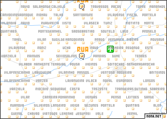
Rua (Braga, Portugal)Rua is a town in the Braga region of Portugal. An overview map of the region around Rua is displayed below.
regional and 3d topo map of Rua, Portugal ::
Rua airports ::
The nearest airport is OPO - Porto, located 38.5 km south west of Rua.
Other airports nearby include VRL - Vila Real (72.8 km south east), VGO - Vigo (74.6 km north), SCQ - Santiago (147.9 km north), BGC - Braganca (152.7 km east), Nearby towns ::
Cabanelas (1.9km north) //
São Gens (1.9km north) //
Boa Vista (1.4km east) //
Padim da Graça (1.4km east) //
Paço (1.9km south) //
Paulinos (1.9km south) //
Sobrado (2.3km north east) //
Pousa (2.3km south west) //
Vieiros (2.3km south east) //
Mire de Tibães (2.3km south east) //
Parada de Tibães (2.8km east) //
Quintão (2.8km west) //
Lama (2.8km west) //
Areias (2.8km west) //
Panóias (2.8km east) //
Seixos Alvos (2.8km west) //
Espinheira (3.7km north) //
Monte do Porto (3.7km south) //
Martim de Além (3.7km south) //
Passos (3.7km south) //
Cabrita (3.7km south) //
Areosa (3.3km north west) //
Ucha (3.3km north west) //
Merelim (3.3km north east) //
Semelhe (3.3km south east) //
Mangoeiros (4.0km north) //
Ermida (4.0km north) //
Fontainha (4.0km north) //
Pomares (4.0km south) //
[all distances 'as the bird flies' and approximate]  Places with similar names to Rua, Portugal ::
Disclaimer :: Information on this page comes without warranty of any kind |
||
|
Where is Rua? Elevation and coordinates ::
Latitude (lat): 41°34'0"N Longitude (lon): 8°30'0"W
Elevation (approx.): 38m (map arrows pan, magnifying glasses zoom) |
||
|
Visiting Rua? Hotel/Accommodation ::
Book a hotel in Rua Travel Guide ::
Buy a travel guide for Portugal rental cars ::
car rental offers GPS waypoint ::
download a GPX waypoint (PoI) of Rua for your GPS receiver
|
||