|
search place name
|
||
Tendais (Viseu, Portugal)Tendais is a town in the Viseu region of Portugal. An overview map of the region around Tendais is displayed below.
regional and 3d topo map of Tendais, Portugal ::

Tendais airports ::
The nearest airport is VRL - Vila Real, located 36.0 km north east of Tendais.
Other airports nearby include OPO - Porto (56.7 km west), VGO - Vigo (138.0 km north), BGC - Braganca (142.5 km north east), SCQ - Santiago (205.5 km north), Nearby towns ::
Valemelhorado (0.0km north) //
Ruivais (0.0km north) //
Paredes (0.0km north) //
Castanheira (1.9km north) //
Paçô (1.9km north) //
Fundoais (1.4km west) //
Pias (1.4km west) //
Montão (1.4km east) //
Ferreiros de Tendais (1.9km south) //
Aldeia (1.9km south) //
Covelas (1.9km south) //
Oliveira do Douro (2.3km north east) //
Finzes (2.3km north east) //
Boassas (2.3km north west) //
Vila Nova (2.3km north east) //
Mosteirô (2.3km north west) //
Avitouro (2.3km south west) //
Lagarelhos (2.3km south west) //
Plisqueira (2.3km south west) //
Travassos de Cima (2.8km west) //
Sinfães (2.8km west) //
Cabeço (2.8km east) //
Ancede (3.7km north) //
Canastrês (3.7km north) //
Adega (3.7km north) //
Valverde (3.7km south) //
Mourelos (3.7km south) //
Porto Antigo (3.4km north west) //
Souto do Rio (3.4km north west) //
[all distances 'as the bird flies' and approximate] 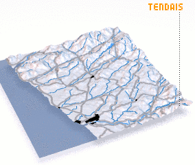 Places with similar names to Tendais, Portugal ::
Disclaimer :: Information on this page comes without warranty of any kind |
||
|
Where is Tendais? Elevation and coordinates ::
Latitude (lat): 41°4'0"N Longitude (lon): 8°3'0"W
Elevation (approx.): 470m (map arrows pan, magnifying glasses zoom) |
||
|
Visiting Tendais? Hotel/Accommodation ::
Book a hotel in Tendais Travel Guide ::
Buy a travel guide for Portugal rental cars ::
car rental offers GPS waypoint ::
download a GPX waypoint (PoI) of Tendais for your GPS receiver
|
||