|
search place name
|
||
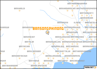
Ban Song Phi Nong (Rayong, Thailand)Ban Song Phi Nong is a town in the Rayong region of Thailand. An overview map of the region around Ban Song Phi Nong is displayed below.
regional and 3d topo map of Ban Song Phi Nong, Thailand ::
Ban Song Phi Nong airports ::
The nearest airport is UTP - Rayong U Taphao Intl, located 59.7 km west of Ban Song Phi Nong.
Other airports nearby include BKK - Bangkok Intl (164.3 km north west), HHQ - Prachuap Khiri Khan Hua Hin (174.1 km west), Nearby towns ::
Ban Song Salung (4.1km south east) //
Ban Wang Duan (5.4km east) //
Ban Khlong Kha (1) (5.7km east) //
Ban Nong Ri (1) (6.6km north east) //
Ban Chang Thong (6.6km south east) //
Ban Wang Lang (6.6km south east) //
Ban Wang Hin (3) (7.2km east) //
Ban Krachet (7.5km west) //
Ban Nong Sanom (7.5km east) //
Ban Wang Katha (7.5km west) //
Ban Khlong Thurian (7.6km south) //
Ban Ta Lan (8.1km south west) //
Ban Samo Phrong (8.2km south east) //
Ban Takat Ta Lua (9.2km south east) //
Ban Klaeng Bon (9.2km south west) //
Ban Nong Chang Tai (9.2km south east) //
Ban Samet Ngam (9.1km south east) //
[all distances 'as the bird flies' and approximate]  Places with similar names to Ban Song Phi Nong, Thailand ::
// Ban Song Phi Nong (TH)
// Ban Song Phi Nong (TH)
// Ban Song Phi Nong (TH)
// Ban Song Phi Nong (TH)
// Ban Song Phi Nong (TH)
// Ban Song Phi Nong (TH)
// Ban Song Phi Nong (TH)
// Ban Song Phi Nong (TH)
Disclaimer :: Information on this page comes without warranty of any kind |
||
|
Where is Ban Song Phi Nong? Elevation and coordinates ::
Latitude (lat): 12°45'0"N Longitude (lon): 101°33'0"E
Elevation (approx.): 27m (map arrows pan, magnifying glasses zoom) |
||
|
Visiting Ban Song Phi Nong? Hotel/Accommodation ::
Book a hotel in Ban Song Phi Nong Travel Guide ::
Buy a travel guide for Thailand rental cars ::
car rental offers GPS waypoint ::
download a GPX waypoint (PoI) of Ban Song Phi Nong for your GPS receiver
|
||