|
search place name
|
||
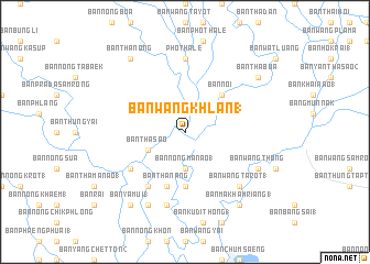
Ban Wang Khlan (1) (Phichit, Thailand)Ban Wang Khlan (1) is a town in the Phichit region of Thailand. An overview map of the region around Ban Wang Khlan (1) is displayed below.
regional and 3d topo map of Ban Wang Khlan (1), Thailand ::
Ban Wang Khlan (1) airports ::
The nearest airport is PHS - Phitsanulok, located 84.8 km north of Ban Wang Khlan (1).
Other airports nearby include LOE - Loei (221.1 km north east), NAK - Nakhon Ratchasima Khorat (228.4 km south east), Nearby towns ::
Ban Nong Ma Nao (1) (3.7km south) //
Ban Tha Sao (4.0km south west) //
Ban Noi (5.1km north east) //
Ban Wang Daeng (5.6km south) //
Ban Tha Nang (5.8km south) //
Ban Hang Ket (6.5km south west) //
Ban Nong Dong (1) (6.6km south west) //
Pho Thale (7.4km north) //
Ban Dong Kraphi (1) (7.6km south) //
Ban Wang Ta Rot (1) (7.7km south east) //
Ban Laem Yang (1) (7.7km south east) //
Ban Wang Thong (8.0km south east) //
Ban Wang Won (8.2km south west) //
Ban Thanong (9.1km north west) //
Ban Tha Bua (9.0km north east) //
Ban Makham Riang (1) (9.1km south east) //
Ban Ya Mui (1) (9.1km south west) //
Ban Phang Noi (9.1km south west) //
[all distances 'as the bird flies' and approximate]  Places with similar names to Ban Wang Khlan (1), Thailand :: Disclaimer :: Information on this page comes without warranty of any kind |
||
|
Where is Ban Wang Khlan (1)? Elevation and coordinates ::
Latitude (lat): 16°1'0"N Longitude (lon): 100°16'0"E
Elevation (approx.): 35m (map arrows pan, magnifying glasses zoom) |
||
|
Visiting Ban Wang Khlan (1)? Hotel/Accommodation ::
Book a hotel in Ban Wang Khlan (1) Travel Guide ::
Buy a travel guide for Thailand rental cars ::
car rental offers GPS waypoint ::
download a GPX waypoint (PoI) of Ban Wang Khlan (1) for your GPS receiver
|
||