|
search place name
|
||
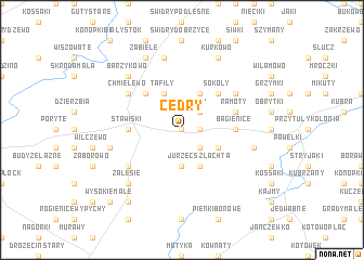
Cedry (Poland)Cedry is a town in Poland. An overview map of the region around Cedry is displayed below.
regional and 3d topo map of Cedry, Poland ::
Cedry airports ::
The nearest airport is WAW - Warsaw Okecie, located 157.4 km south west of Cedry.
Other airports nearby include KGD - Kaliningrad Khrabrovo (199.5 km north west), Nearby towns ::
Rostki (0.0km north) //
Żelazki (1.1km east) //
Lisy (2.2km north east) //
Cwaliny (2.2km south east) //
Jurzec (3.7km south) //
Tafiły (3.9km north) //
Rogale (3.9km north) //
Mieczki Sucholaszczki (2.9km south east) //
Jurzec Szlachta (3.9km south) //
Michny (4.3km north west) //
Sokoły (4.3km north east) //
Bagienice (3.3km east) //
Stawiski (3.3km west) //
Ramoty (3.8km north east) //
Romany (5.0km north east) //
Chmielewo (5.0km north west) //
Karwowo (5.0km south west) //
Dzięgiele (7.5km north) //
Olszewo Góra (4.8km south east) //
Budy Stawiskie (4.8km south west) //
Barzykowo (6.5km north west) //
Zalesie (6.5km south west) //
Zabiele (7.7km north) //
Kurkowo (7.7km north) //
Kobylin (8.1km south west) //
Wysokie Małe (8.6km south west) //
[all distances 'as the bird flies' and approximate]  Places with similar names to Cedry, Poland ::
Disclaimer :: Information on this page comes without warranty of any kind |
||
|
Where is Cedry? Elevation and coordinates ::
Latitude (lat): 53°22'0"N Longitude (lon): 22°12'0"E
Elevation (approx.): 176m (map arrows pan, magnifying glasses zoom) |
||
|
Visiting Cedry? Hotel/Accommodation ::
Book a hotel in Cedry Travel Guide ::
Buy a travel guide for Poland rental cars ::
car rental offers GPS waypoint ::
download a GPX waypoint (PoI) of Cedry for your GPS receiver
|
||