|
search place name
|
||
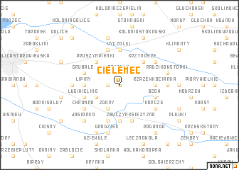
Cielemęc (Poland)Cielemęc is a town in Poland. An overview map of the region around Cielemęc is displayed below.
regional and 3d topo map of Cielemęc, Poland ::
Cielemęc airports ::
The nearest airport is WAW - Warsaw Okecie, located 100.4 km west of Cielemęc.
Nearby towns ::
Choja (0.0km north) //
Tarcze (1.1km west) //
Czuryły (1.9km north) //
Osiny (2.2km north west) //
Olędy (2.2km north east) //
Zdany (3.9km south) //
Ługi Rętki (2.9km south west) //
Pruszyn Pieńki (4.3km north west) //
Krzymosze (4.3km north east) //
Zbuczyn Poduchowny (5.6km south) //
Zbuczyn (5.6km south) //
Lipiny (3.4km west) //
Rzążew (3.4km east) //
Rzążew Kocianka (3.4km east) //
Wyczółki (5.6km north) //
Zbuczyn Kolonia (5.7km south) //
Rzążew Bugaje (3.9km south east) //
Ługi Wielkie (3.9km south west) //
Bzów (3.9km south east) //
Rzążew Świstówka (3.9km south east) //
Pruszyn (5.7km north) //
Zbuczyn Księżyzna (5.7km south) //
Grubale (3.9km north west) //
Karcze (5.0km south east) //
Chromna (5.0km south west) //
Wielgorz (5.0km north east) //
Joachimów (4.6km west) //
Radzików Kornica (4.6km east) //
Grodzisk (7.5km south) //
[all distances 'as the bird flies' and approximate]  Places with similar names to Cielemęc, Poland ::
Disclaimer :: Information on this page comes without warranty of any kind |
||
|
Where is Cielemęc? Elevation and coordinates ::
Latitude (lat): 52°8'0"N Longitude (lon): 22°26'0"E
Elevation (approx.): 169m (map arrows pan, magnifying glasses zoom) |
||
|
Visiting Cielemęc? Hotel/Accommodation ::
Book a hotel in Cielemęc Travel Guide ::
Buy a travel guide for Poland rental cars ::
car rental offers GPS waypoint ::
download a GPX waypoint (PoI) of Cielemęc for your GPS receiver
|
||