|
search place name
|
||
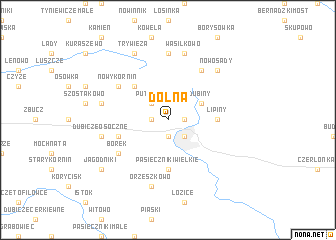
Dolna (Poland)Dolna is a town in Poland. An overview map of the region around Dolna is displayed below.
regional and 3d topo map of Dolna, Poland ::
Nearby towns ::
Placówka (1.1km east) //
Wygoda (1.1km west) //
Górna (1.9km south) //
Hajnówka (2.2km south east) //
Putyska (2.2km north west) //
Dubiny (2.9km north east) //
Czyżyki (4.3km north west) //
Pasieczniki Wielkie (5.6km south) //
Lipiny (3.4km east) //
Chytra (3.8km south west) //
Dubińska Ferma (6.0km north) //
Nowy Kornin (5.0km north west) //
Borek (5.0km south west) //
Kotówka (7.4km north) //
Wasilkowo (7.5km north) //
Orzeszkowo (7.5km south) //
Dubicze Osoczne (4.9km west) //
Nowoberezowo (4.9km west) //
Nowosady (6.5km north east) //
Trywieża (7.7km north) //
Jagodniki (7.1km south west) //
[all distances 'as the bird flies' and approximate]  Places with similar names to Dolna, Poland ::
Disclaimer :: Information on this page comes without warranty of any kind |
||
|
Where is Dolna? Elevation and coordinates ::
Latitude (lat): 52°45'0"N Longitude (lon): 23°34'0"E
Elevation (approx.): 160m (map arrows pan, magnifying glasses zoom) |
||
|
Visiting Dolna? Hotel/Accommodation ::
Book a hotel in Dolna Travel Guide ::
Buy a travel guide for Poland rental cars ::
car rental offers GPS waypoint ::
download a GPX waypoint (PoI) of Dolna for your GPS receiver
|
||