|
search place name
|
||
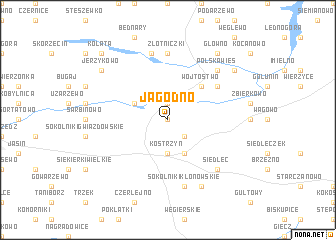
Jagodno (Poland)Jagodno is a town in Poland. An overview map of the region around Jagodno is displayed below.
regional and 3d topo map of Jagodno, Poland ::
Jagodno airports ::
The nearest airport is POZ - Poznan Lawica, located 28.9 km west of Jagodno.
Other airports nearby include IEG - Zielona Gora Babimost (104.3 km west), WRO - Wroclaw Strachowice (150.2 km south), GDN - Gdansk Lecha Walesy (231.0 km north), KTW - Katowice Pyrzowice (252.3 km south east), Nearby towns ::
Glinka Szlachecka (0.0km north) //
Promno (1.9km north) //
Glinka Duchowna (2.2km south east) //
Glinka (2.2km south east) //
Kostrzyń (3.7km south) //
Góra (2.9km north west) //
Iwno (3.9km south) //
Wójtostwo (4.3km north east) //
Pobiedziska (5.0km north east) //
Złotniczki (7.4km north) //
Sokolniki Klonowskie (7.5km south) //
Jerzyn (7.5km north) //
Polska Wieś (6.5km north east) //
Siedlec (6.5km south east) //
Sokolniki (7.8km south) //
Bociniec (7.2km north east) //
Jerzykowo (7.2km north west) //
Główno (8.2km north east) //
Kołata (8.7km north west) //
[all distances 'as the bird flies' and approximate]  Places with similar names to Jagodno, Poland ::
Disclaimer :: Information on this page comes without warranty of any kind |
||
|
Where is Jagodno? Elevation and coordinates ::
Latitude (lat): 52°26'0"N Longitude (lon): 17°15'0"E
Elevation (approx.): 94m (map arrows pan, magnifying glasses zoom) |
||
|
Visiting Jagodno? Hotel/Accommodation ::
Book a hotel in Jagodno Travel Guide ::
Buy a travel guide for Poland rental cars ::
car rental offers GPS waypoint ::
download a GPX waypoint (PoI) of Jagodno for your GPS receiver
|
||