|
search place name
|
||
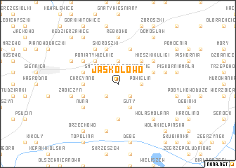
Jaskółowo (Poland)Jaskółowo is a town in Poland. An overview map of the region around Jaskółowo is displayed below.
regional and 3d topo map of Jaskółowo, Poland ::
Jaskółowo airports ::
The nearest airport is WAW - Warsaw Okecie, located 44.7 km south of Jaskółowo.
Nearby towns ::
Smogorzewo (1.9km north) //
Smogorzewo Włościańskie (1.9km north) //
Smogorzewo Pańskie (1.9km north) //
Błędostowo (2.2km north east) //
Zabłocie (2.2km south east) //
Dąbrowa (2.2km north west) //
Popowo Borowe (2.2km south west) //
Powielin (2.3km east) //
Kamionna (3.7km north) //
Guty (3.9km south) //
Krzyczki Pieniążki (2.9km north west) //
Mieszki (4.3km north east) //
Poniaty Wielkie (4.3km north west) //
Stanisławowo (5.6km south) //
Chreynno (3.4km west) //
Krzyczki Żabiczki (3.9km north west) //
Łosiewo (3.9km north east) //
Pawłowo (5.7km north) //
Chechnówka (3.9km south west) //
Kukarzewo (3.9km south west) //
Skoroszki (5.7km north) //
Krzyczki (5.0km north west) //
Mieszki Kuligi (5.0km north east) //
Nuna (5.0km south west) //
Lorcin (5.0km south west) //
Poniaty Keczki (6.0km north) //
Poniaty Cibory (6.0km north) //
Rębkowo (7.4km north) //
Ciepielin (4.9km east) //
[all distances 'as the bird flies' and approximate]  Places with similar names to Jaskółowo, Poland :: Disclaimer :: Information on this page comes without warranty of any kind |
||
|
Where is Jaskółowo? Elevation and coordinates ::
Latitude (lat): 52°34'0"N Longitude (lon): 20°55'0"E
Elevation (approx.): 98m (map arrows pan, magnifying glasses zoom) |
||
|
Visiting Jaskółowo? Hotel/Accommodation ::
Book a hotel in Jaskółowo Travel Guide ::
Buy a travel guide for Poland rental cars ::
car rental offers GPS waypoint ::
download a GPX waypoint (PoI) of Jaskółowo for your GPS receiver
|
||