|
search place name
|
||
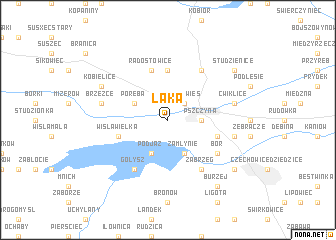
Łąka (Poland)Łąka is a town in Poland. An overview map of the region around Łąka is displayed below.
regional and 3d topo map of Łąka, Poland ::
Łąka airports ::
The nearest airport is KTW - Katowice Pyrzowice, located 57.7 km north of Łąka.
Other airports nearby include KRK - Krakow Balice (63.4 km east), OSR - Ostrava Mosnov (65.3 km south west), PRV - Prerov (124.6 km south west), TAT - Poprad Tatry (138.1 km south east), Nearby towns ::
Stara Wieś (2.2km north east) //
Pszczyna (2.4km east) //
Zamłynie (3.9km south) //
Poręba (3.0km north west) //
Podjaz (3.9km south) //
Czarków (5.6km north) //
Goczałkowice Zdrój (4.0km south east) //
Wisła Wielka (4.0km south west) //
Radostowice (5.7km north) //
Mościsko (6.1km south east) //
Podlesie (6.1km south east) //
Zabrzeg (6.1km south east) //
Piasek (6.0km north east) //
Gołysz (6.1km south west) //
Bór (5.2km south east) //
Ćwiklice (5.1km east) //
Goczałkowice Dolne (5.1km east) //
Brzeźce (5.1km west) //
Kobielice (6.0km north west) //
Renardowice (7.3km south east) //
Studzienice (7.3km north east) //
Burzej (8.2km south east) //
[all distances 'as the bird flies' and approximate]  Places with similar names to Łąka, Poland ::
Disclaimer :: Information on this page comes without warranty of any kind |
||
|
Where is Łąka? Elevation and coordinates ::
Latitude (lat): 49°58'0"N Longitude (lon): 18°55'0"E
Elevation (approx.): 250m (map arrows pan, magnifying glasses zoom) |
||
|
Visiting Łąka? Hotel/Accommodation ::
Book a hotel in Łąka Travel Guide ::
Buy a travel guide for Poland rental cars ::
car rental offers GPS waypoint ::
download a GPX waypoint (PoI) of Łąka for your GPS receiver
|
||