|
search place name
|
||
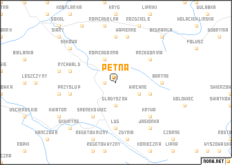
Pętna (Poland)Pętna is a town in Poland. An overview map of the region around Pętna is displayed below.
regional and 3d topo map of Pętna, Poland ::
Pętna airports ::
The nearest airport is RZE - Rzeszow Jasionka, located 81.1 km north east of Pętna.
Other airports nearby include TAT - Poprad Tatry (92.6 km south west), KSC - Kosice (100.5 km south), KRK - Krakow Balice (120.8 km north west), SUJ - Satu Mare (239.1 km south east), Nearby towns ::
Małastów (1.2km west) //
Gładyszów (3.7km south) //
Ropica Górna (3.9km north) //
Wirchne (3.0km south east) //
Banica (4.1km south east) //
Przegonina (5.2km north east) //
Smerekowiec (6.1km south west) //
Męcina Wielka (7.4km north) //
Bartne (4.8km east) //
Ług (7.4km south) //
Wapienne (7.5km north) //
Rychwałd (5.2km west) //
Przysłup (5.2km west) //
Krywa (6.6km south east) //
Jasionka (8.2km south east) //
Sękowa (7.3km north west) //
Bednarka (8.8km north east) //
Skwirtne (8.8km south west) //
[all distances 'as the bird flies' and approximate]  Places with similar names to Pętna, Poland ::
Disclaimer :: Information on this page comes without warranty of any kind |
||
|
Where is Pętna? Elevation and coordinates ::
Latitude (lat): 49°34'0"N Longitude (lon): 21°16'0"E
Elevation (approx.): 649m (map arrows pan, magnifying glasses zoom) |
||
|
Visiting Pętna? Hotel/Accommodation ::
Book a hotel in Pętna Travel Guide ::
Buy a travel guide for Poland rental cars ::
car rental offers GPS waypoint ::
download a GPX waypoint (PoI) of Pętna for your GPS receiver
|
||