|
search place name
|
||
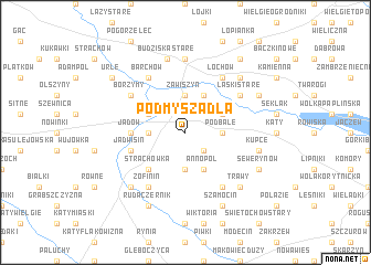
Podmyszadła (Poland)Podmyszadła is a town in Poland. An overview map of the region around Podmyszadła is displayed below.
regional and 3d topo map of Podmyszadła, Poland ::
Podmyszadła airports ::
The nearest airport is WAW - Warsaw Okecie, located 59.2 km south west of Podmyszadła.
Nearby towns ::
Świętochów Nowy (2.2km south east) //
Zawiszyn (3.7km north) //
Borki (2.3km west) //
Rozalin (3.7km south) //
Podbale (2.3km east) //
Wójty (2.9km north west) //
Starowola (3.9km north) //
Myszadła (2.9km north east) //
Annopol (3.9km south) //
Strachówka (4.3km south west) //
Jadów (3.4km west) //
Jadwisin (3.9km south west) //
Zofinin (6.0km south) //
Laski Stare (5.0km north east) //
Borzymy (5.0km north west) //
Barchów (6.0km north) //
Marysin (6.0km south) //
Łochów (6.0km north) //
Budziska Nowe (7.4km north) //
Budziska Stare (7.5km north) //
Budziska (7.5km north) //
Kupce (4.9km east) //
Trawy (6.5km south east) //
Czernik (6.5km south west) //
Chrzepta (6.5km north east) //
Laski Nowe (5.8km north east) //
Ruda Czernik (7.8km south) //
Laski (5.8km north east) //
Sewerynów (5.8km south east) //
[all distances 'as the bird flies' and approximate]  Places with similar names to Podmyszadła, Poland :: Disclaimer :: Information on this page comes without warranty of any kind |
||
|
Where is Podmyszadła? Elevation and coordinates ::
Latitude (lat): 52°28'0"N Longitude (lon): 21°41'0"E
Elevation (approx.): 105m (map arrows pan, magnifying glasses zoom) |
||
|
Visiting Podmyszadła? Hotel/Accommodation ::
Book a hotel in Podmyszadła Travel Guide ::
Buy a travel guide for Poland rental cars ::
car rental offers GPS waypoint ::
download a GPX waypoint (PoI) of Podmyszadła for your GPS receiver
|
||