|
search place name
|
||
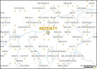
Rożniaty (Poland)Rożniaty is a town in Poland. An overview map of the region around Rożniaty is displayed below.
regional and 3d topo map of Rożniaty, Poland ::
Rożniaty airports ::
The nearest airport is RZE - Rzeszow Jasionka, located 55.1 km south east of Rożniaty.
Other airports nearby include KRK - Krakow Balice (124.0 km west), TAT - Poprad Tatry (173.9 km south west), WAW - Warsaw Okecie (195.5 km north), KSC - Kosice (197.4 km south), Nearby towns ::
Młodochów (1.9km south) //
Krzemienica (1.2km west) //
Wola Zdakowska (2.2km south west) //
Niekurza (2.2km north west) //
Matiaszów (3.7km north) //
Sworoń (3.7km north) //
Staszówek (3.7km north) //
Kębłów (2.4km east) //
Trzcianka Kolonia (3.9km north) //
Tarnówek (3.0km south east) //
Przykop (3.9km north) //
Zaduszniki (3.9km north) //
Mikołajów (5.6km north) //
Babicha (5.6km south) //
Borki Nizińskie (5.6km south) //
Trzcianka (5.7km north) //
Kliszów (4.0km south west) //
Gawłuszowice (4.0km south west) //
Brzyście (5.7km south) //
Nakol (5.7km north) //
Niekrasów (6.0km north west) //
Jaślany (5.1km south east) //
Tursko Wielkie (5.1km north west) //
Domacyny (5.1km north east) //
Padew (4.7km east) //
Wojków (5.1km east) //
Tuszów Narodowy (7.8km south) //
Strużki (6.0km north west) //
Lipnik (7.8km north) //
[all distances 'as the bird flies' and approximate]  Places with similar names to Rożniaty, Poland ::
Disclaimer :: Information on this page comes without warranty of any kind |
||
|
Where is Rożniaty? Elevation and coordinates ::
Latitude (lat): 50°26'0"N Longitude (lon): 21°26'0"E
Elevation (approx.): 151m (map arrows pan, magnifying glasses zoom) |
||
|
Visiting Rożniaty? Hotel/Accommodation ::
Book a hotel in Rożniaty Travel Guide ::
Buy a travel guide for Poland rental cars ::
car rental offers GPS waypoint ::
download a GPX waypoint (PoI) of Rożniaty for your GPS receiver
|
||