|
search place name
|
||
Sławoszewek (Poland)Sławoszewek is a town in Poland. An overview map of the region around Sławoszewek is displayed below.
regional and 3d topo map of Sławoszewek, Poland ::

Sławoszewek airports ::
The nearest airport is POZ - Poznan Lawica, located 93.6 km west of Sławoszewek.
Other airports nearby include WRO - Wroclaw Strachowice (168.9 km south west), KTW - Katowice Pyrzowice (221.0 km south), GDN - Gdansk Lecha Walesy (222.7 km north), Nearby towns ::
Cegielnia (1.9km south) //
Wielkopole (2.2km north east) //
Obrona (3.7km south) //
Sławoszewo (2.3km east) //
Izabelin (3.7km north) //
Gogolina Stara (3.7km north) //
Kleczew (2.9km south west) //
Rostoka (2.9km north west) //
Stogi (2.9km north east) //
Kaliska (3.9km north) //
Ostrowąż (4.3km north east) //
Góry (4.3km north east) //
Biskupie (3.4km east) //
Gogolina Nowa (5.6km north) //
Gogolina (5.6km north) //
Goranin (3.9km south east) //
Rożnowa (3.9km south east) //
Alinowo (3.9km north west) //
Wiśniewa (5.7km north) //
Sławęcin (5.0km south east) //
Józwin (6.0km south) //
Kalinowiec (4.5km west) //
Kopydłowo (7.5km north) //
Makarowo (6.5km south east) //
Wola Spławiecka (6.5km north west) //
Kazimierz Biskupi (7.8km south) //
Stefanowo (5.9km south west) //
Dąbrowa Duża (5.9km south east) //
Dąbrowa (5.9km south east) //
[all distances 'as the bird flies' and approximate] 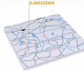 Places with similar names to Sławoszewek, Poland :: Disclaimer :: Information on this page comes without warranty of any kind |
||
|
Where is Sławoszewek? Elevation and coordinates ::
Latitude (lat): 52°23'0"N Longitude (lon): 18°12'0"E
Elevation (approx.): 94m (map arrows pan, magnifying glasses zoom) |
||
|
Visiting Sławoszewek? Hotel/Accommodation ::
Book a hotel in Sławoszewek Travel Guide ::
Buy a travel guide for Poland rental cars ::
car rental offers GPS waypoint ::
download a GPX waypoint (PoI) of Sławoszewek for your GPS receiver
|
||