|
search place name
|
||
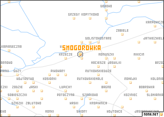
Smogorówka (Poland)Smogorówka is a town in Poland. An overview map of the region around Smogorówka is displayed below.
regional and 3d topo map of Smogorówka, Poland ::
Smogorówka airports ::
The nearest airport is WAW - Warsaw Okecie, located 198.2 km south west of Smogorówka.
Nearby towns ::
Smogorówka Goniądzka (0.0km north) //
Smogorówka Dolistowska (0.0km north) //
Dolistowo Nowe (3.7km north) //
Krzecze (2.2km west) //
Wroceń (2.9km north west) //
Dolistowo (3.9km north) //
Maciesze (2.9km south east) //
Dolistowo Stare (4.3km north east) //
Białosuknia (4.3km south west) //
Rutkowskie Duże (4.3km south east) //
Moniuszki (3.3km east) //
Rutkowskie Małe (5.7km south) //
Piwowary (5.0km south west) //
Jedeszki (4.4km east) //
Jaświłki (4.8km south east) //
Jaświły (6.5km south east) //
Klewianka (5.8km south west) //
Łupichy (7.7km south) //
Kosiorki (7.1km south west) //
Bagno (8.1km south east) //
[all distances 'as the bird flies' and approximate]  Places with similar names to Smogorówka, Poland ::
Disclaimer :: Information on this page comes without warranty of any kind |
||
|
Where is Smogorówka? Elevation and coordinates ::
Latitude (lat): 53°31'0"N Longitude (lon): 22°53'0"E
Elevation (approx.): 124m (map arrows pan, magnifying glasses zoom) |
||
|
Visiting Smogorówka? Hotel/Accommodation ::
Book a hotel in Smogorówka Travel Guide ::
Buy a travel guide for Poland rental cars ::
car rental offers GPS waypoint ::
download a GPX waypoint (PoI) of Smogorówka for your GPS receiver
|
||