|
search place name
|
||
Szaleniec (Poland)Szaleniec is a town in Poland. An overview map of the region around Szaleniec is displayed below.
regional and 3d topo map of Szaleniec, Poland ::

Szaleniec airports ::
The nearest airport is GDN - Gdansk Lecha Walesy, located 64.6 km north west of Szaleniec.
Other airports nearby include KGD - Kaliningrad Khrabrovo (126.3 km north east), WAW - Warsaw Okecie (238.1 km south east), Nearby towns ::
Stalewo (2.1km south east) //
Złotnica (2.2km east) //
Oleśno (3.9km north) //
Rozgart (2.9km north east) //
Żuławka (4.3km south west) //
Fiszewo (4.3km north west) //
Jasna (4.3km south east) //
Gronowo (4.3km north east) //
Kławki (3.3km west) //
Mojkowo (5.6km north) //
Błotnica (5.6km north) //
Złotowo (3.8km south west) //
Szlagnowo (3.8km north west) //
Różany (4.9km north east) //
Krzyżanowo (4.4km west) //
Stare Pole (4.4km west) //
Budzisz (7.4km south) //
Zwierzno (4.7km south east) //
Nowy Dwór (7.5km north) //
Ząbrowo (6.4km north west) //
Trankwice (7.7km south) //
Jasionno (5.7km north east) //
Czarna Grobla (7.7km north) //
Krzewiny (7.7km north) //
Mechnica (7.7km north) //
Czerwonka (8.1km north west) //
[all distances 'as the bird flies' and approximate] 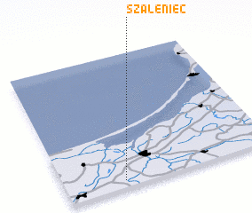 Places with similar names to Szaleniec, Poland ::
Disclaimer :: Information on this page comes without warranty of any kind |
||
|
Where is Szaleniec? Elevation and coordinates ::
Latitude (lat): 54°3'0"N Longitude (lon): 19°17'0"E
Elevation (approx.): -3m (map arrows pan, magnifying glasses zoom) |
||
|
Visiting Szaleniec? Hotel/Accommodation ::
Book a hotel in Szaleniec Travel Guide ::
Buy a travel guide for Poland rental cars ::
car rental offers GPS waypoint ::
download a GPX waypoint (PoI) of Szaleniec for your GPS receiver
|
||