|
search place name
|
||
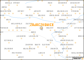
Zajączkowice (Poland)Zajączkowice is a town in Poland. An overview map of the region around Zajączkowice is displayed below.
regional and 3d topo map of Zajączkowice, Poland ::
Zajączkowice airports ::
The nearest airport is RZE - Rzeszow Jasionka, located 54.9 km east of Zajączkowice.
Other airports nearby include KRK - Krakow Balice (106.4 km west), TAT - Poprad Tatry (128.5 km south west), KSC - Kosice (150.6 km south), Nearby towns ::
Rędziny (2.4km east) //
Lipiny (2.4km east) //
Borki (3.0km south west) //
Łęki Dolne (4.4km south west) //
Machowa (3.6km west) //
Czarna (5.6km north) //
Golemki (5.6km north) //
Chotowa (3.6km east) //
Zdziary (4.0km north west) //
Głowaczowa (5.1km north east) //
Pilzno (6.0km south east) //
Jaźwiny (7.5km north) //
Parkosz (5.1km east) //
Słotowa (7.5km south) //
Budyń (7.5km south) //
Polesie (6.6km north west) //
Karolówka (6.6km north east) //
Borowa (7.8km north) //
Jawornik Stary (7.8km north) //
Zwiernik (8.2km south west) //
Świercze (8.8km north east) //
[all distances 'as the bird flies' and approximate]  Places with similar names to Zajączkowice, Poland ::
// Zajączkowice (PL)
Disclaimer :: Information on this page comes without warranty of any kind |
||
|
Where is Zajączkowice? Elevation and coordinates ::
Latitude (lat): 50°1'0"N Longitude (lon): 21°16'0"E
Elevation (approx.): 205m (map arrows pan, magnifying glasses zoom) |
||
|
Visiting Zajączkowice? Hotel/Accommodation ::
Book a hotel in Zajączkowice Travel Guide ::
Buy a travel guide for Poland rental cars ::
car rental offers GPS waypoint ::
download a GPX waypoint (PoI) of Zajączkowice for your GPS receiver
|
||