|
search place name
|
||
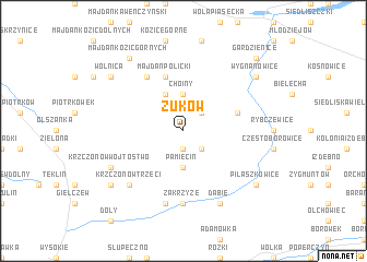
Żuków (Poland)Żuków is a town in Poland. An overview map of the region around Żuków is displayed below.
regional and 3d topo map of Żuków, Poland ::
Żuków airports ::
The nearest airport is RZE - Rzeszow Jasionka, located 116.1 km south west of Żuków.
Other airports nearby include LWO - Lvov Lviv Intl (159.3 km south east), WAW - Warsaw Okecie (178.1 km north west), Nearby towns ::
Walentynów (1.9km south) //
Pustelnik (2.2km south east) //
Bujanica (2.2km north east) //
Policzyzna (2.2km north east) //
Pamięcin (3.7km south) //
Choiny (3.7km north) //
Antoniówka (3.9km north) //
Majdan Policki (5.7km north) //
Kolonia Stryjna (4.0km north east) //
Borkowszczyzna (6.0km north west) //
Zakrzyźe (7.4km south) //
Sobieska Wola (7.5km south) //
Krzczonów Trzeci (6.6km south west) //
Krzczonów-Wójtostwo (6.0km south west) //
Dąbie (7.8km south) //
Wolnica (7.3km north west) //
Borzęcinek (7.3km south west) //
Majdan Kozic Górnych (8.2km north west) //
Wola Gardzienicka (7.3km north east) //
Wygnanowice (7.3km north east) //
Pilaszkowice (7.3km south east) //
Gardzienice (8.8km north east) //
[all distances 'as the bird flies' and approximate]  Places with similar names to Żuków, Poland ::
Disclaimer :: Information on this page comes without warranty of any kind |
||
|
Where is Żuków? Elevation and coordinates ::
Latitude (lat): 51°2'0"N Longitude (lon): 22°47'0"E
Elevation (approx.): 229m (map arrows pan, magnifying glasses zoom) |
||
|
Visiting Żuków? Hotel/Accommodation ::
Book a hotel in Żuków Travel Guide ::
Buy a travel guide for Poland rental cars ::
car rental offers GPS waypoint ::
download a GPX waypoint (PoI) of Żuków for your GPS receiver
|
||