|
search place name
|
||
Lehnerpuszta (Somogy, Hungary)Lehnerpuszta is a town in the Somogy region of Hungary. An overview map of the region around Lehnerpuszta is displayed below.
regional and 3d topo map of Lehnerpuszta, Hungary ::

Lehnerpuszta airports ::
The nearest airport is MBX - Maribor, located 122.7 km west of Lehnerpuszta.
Other airports nearby include ZAG - Zagreb (128.6 km south west), GRZ - Graz (149.8 km west), OSI - Osijek (167.8 km south east), BUD - Budapest Ferihegy (180.6 km north east), Nearby towns ::
Csákány (0.0km north) //
Szalasztópuszta (1.9km north) //
Andormajor (2.2km south west) //
Szőcsénypuszta (2.5km east) //
Nemesvid (3.9km south) //
Szőkedencs (3.2km north west) //
Somogyzsitfa (3.9km north) //
Sávoly (5.7km north) //
Kisvid (5.7km south) //
Somogysámson (5.7km north) //
Alsóhegy (6.1km south east) //
Hárihegy (6.1km south east) //
Homok (6.1km south east) //
Nagyszakácsi (6.1km south east) //
Gardospuszta (6.7km south west) //
Somogysimonyi (7.5km south west) //
Csonkakőtanya (7.5km south west) //
Tapsony (8.3km south east) //
Horvátkút (7.5km north east) //
[all distances 'as the bird flies' and approximate] 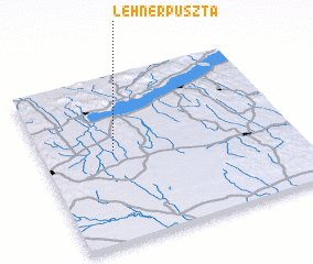 Places with similar names to Lehnerpuszta, Hungary ::
// Lehnerpuszta (HU)
Disclaimer :: Information on this page comes without warranty of any kind |
||
|
Where is Lehnerpuszta? Elevation and coordinates ::
Latitude (lat): 46°32'0"N Longitude (lon): 17°17'0"E
Elevation (approx.): 119m (map arrows pan, magnifying glasses zoom) |
||
|
Visiting Lehnerpuszta? Hotel/Accommodation ::
Book a hotel in Lehnerpuszta Travel Guide ::
Buy a travel guide for Hungary rental cars ::
car rental offers GPS waypoint ::
download a GPX waypoint (PoI) of Lehnerpuszta for your GPS receiver
|
||