|
search place name
|
||
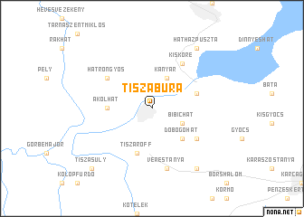
Tiszabura (Jász-Nagykun-Szolnok, Hungary)Tiszabura is a town in the Jász-Nagykun-Szolnok region of Hungary. An overview map of the region around Tiszabura is displayed below.
regional and 3d topo map of Tiszabura, Hungary ::
Tiszabura airports ::
The nearest airport is DEB - Debrecen, located 86.7 km east of Tiszabura.
Other airports nearby include BUD - Budapest Ferihegy (91.4 km west), OMR - Oradea (118.5 km south east), KSC - Kosice (146.7 km north east), ARW - Arad (154.0 km south east), Nearby towns ::
Kanyar (3.9km north) //
Bíbichát (3.1km south east) //
Dobogóhát (4.5km south east) //
Akolhát (3.8km west) //
Pusztataskony (4.2km north east) //
Baltaráta (5.7km south) //
Gyendairét (5.7km south) //
Lejtő (5.7km south) //
Galambdúc (5.7km south) //
Tiszaroff (5.7km south) //
Kisköre (6.1km north east) //
Hatrongyos (5.3km north west) //
Nyakashát (5.3km south east) //
Verestanya (7.5km south) //
Hatházpuszta (8.3km north east) //
Tiszagyenda (8.3km south east) //
Tiszasüly (9.0km south west) //
Jánositanyák (9.0km south west) //
[all distances 'as the bird flies' and approximate] 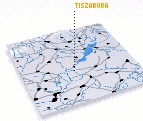 Places with similar names to Tiszabura, Hungary :: Disclaimer :: Information on this page comes without warranty of any kind |
||
|
Where is Tiszabura? Elevation and coordinates ::
Latitude (lat): 47°27'0"N Longitude (lon): 20°28'0"E
Elevation (approx.): 85m (map arrows pan, magnifying glasses zoom) |
||
|
Visiting Tiszabura? Hotel/Accommodation ::
Book a hotel in Tiszabura Travel Guide ::
Buy a travel guide for Hungary rental cars ::
car rental offers GPS waypoint ::
download a GPX waypoint (PoI) of Tiszabura for your GPS receiver
|
||