|
search place name
|
||
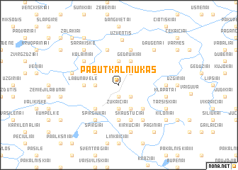
Pabutkalniukas (Lithuania)Pabutkalniukas is a town in Lithuania. An overview map of the region around Pabutkalniukas is displayed below.
regional and 3d topo map of Pabutkalniukas, Lithuania ::
Nearby towns ::
Pabūtkalnis (1.9km south) //
Šlumpiai (2.1km north east) //
Junkilai (2.1km north east) //
Meškuičiai (2.1km south east) //
Gudai (2.1km west) //
Bambalai (3.7km north) //
Žukaičiai (3.7km south) //
Jungiris (2.8km north west) //
Gedruikiai (3.9km north) //
Stonkiškė (3.9km south) //
Šaltropiai (4.3km south west) //
Gorainiai (4.3km south west) //
Audeniai (4.3km south east) //
Labūnavėlė (3.1km west) //
Daukintiškė (5.6km south) //
Kletiškė (5.7km south) //
Skaustučiai (5.7km south) //
Kunigiškiai (5.7km north) //
Želviai (5.7km north) //
Spirgiukai (5.9km south) //
Maldaginė (5.9km south) //
Kolainiai (4.9km north west) //
Užventis (7.1km north) //
Paprūdžiai (4.2km east) //
Kerbedlaukis (4.6km north west) //
Kirkučiai (7.5km south) //
Klapatai (4.6km south east) //
Sarakiškė (6.4km north west) //
Daugėnai (6.4km north east) //
[all distances 'as the bird flies' and approximate]  Places with similar names to Pabutkalniukas, Lithuania :: Disclaimer :: Information on this page comes without warranty of any kind |
||
|
Where is Pabutkalniukas? Elevation and coordinates ::
Latitude (lat): 55°43'0"N Longitude (lon): 22°39'0"E
Elevation (approx.): 147m (map arrows pan, magnifying glasses zoom) |
||
|
Visiting Pabutkalniukas? Hotel/Accommodation ::
Book a hotel in Pabutkalniukas Travel Guide ::
Buy a travel guide for Lithuania rental cars ::
car rental offers GPS waypoint ::
download a GPX waypoint (PoI) of Pabutkalniukas for your GPS receiver
|
||