|
search place name
|
||
Kullametsa (Läänemaa, Estonia)Kullametsa is a town in the Läänemaa region of Estonia. An overview map of the region around Kullametsa is displayed below.
regional and 3d topo map of Kullametsa, Estonia ::

Kullametsa airports ::
The nearest airport is TLL - Tallinn-ulemiste International Tallinn, located 71.6 km north east of Kullametsa.
Other airports nearby include HEM - Helsinki Malmi (161.6 km north), HEL - Helsinki Vantaa (167.0 km north), TKU - Turku (210.8 km north west), Nearby towns ::
Koluvere (3.7km north west) //
Laukna (4.6km north) //
Maidla (5.8km north) //
Silla (3.5km south west) //
Vaikna (5.7km north) //
Salutaguse (6.4km north) //
Kullamaa (3.5km west) //
Tika (7.2km north) //
Leila (6.0km north west) //
Nõmmeküla (5.5km north east) //
Altküla (7.4km south) //
Paisuotsa (8.6km south) //
Väike-Kalju (5.0km north west) //
Suur-Kalju (7.1km north west) //
Kalju (5.8km north west) //
Luiste (5.7km south east) //
Teenuse (7.2km south east) //
Üdruma (8.3km south west) //
[all distances 'as the bird flies' and approximate] 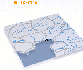 Places with similar names to Kullametsa, Estonia ::
// Calamitas (PH)
// Culmitz (DE)
// Göllmitz (DE)
// Gollmitz (DE)
// Gollmitz (DE)
// Kalemtaş (TR)
// Klimets (UA)
// Kolomiytsy (UA)
// Kolomiytsy (UA)
// Glumitsy (RU)
Disclaimer :: Information on this page comes without warranty of any kind |
||
|
Where is Kullametsa? Elevation and coordinates ::
Latitude (lat): 58°52'39"N Longitude (lon): 24°8'33"E
Elevation (approx.): 31m (map arrows pan, magnifying glasses zoom) |
||
|
Visiting Kullametsa? Hotel/Accommodation ::
Book a hotel in Kullametsa Travel Guide ::
Buy a travel guide for Estonia rental cars ::
car rental offers GPS waypoint ::
download a GPX waypoint (PoI) of Kullametsa for your GPS receiver
|
||