|
search place name
|
||
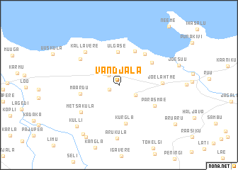
Vandjala (Harjumaa, Estonia)Vandjala is a town in the Harjumaa region of Estonia. An overview map of the region around Vandjala is displayed below.
regional and 3d topo map of Vandjala, Estonia ::
Vandjala airports ::
The nearest airport is TLL - Tallinn-ulemiste International Tallinn, located 14.3 km west of Vandjala.
Other airports nearby include HEM - Helsinki Malmi (90.8 km north), HEL - Helsinki Vantaa (98.0 km north), QVY - Utti (192.3 km north east), TMP - Tampere Pirkkala (234.5 km north), Nearby towns ::
Kroodi (1.0km south west) //
Võerdla (1.8km north west) //
Rebala (2.2km north) //
Kostivere (2.1km south east) //
Ülgase (5.2km north) //
Rannaküla (5.5km north) //
Kurgla (6.1km south) //
Manniva (4.4km north east) //
Maardu (3.4km south west) //
Kostiranna (5.3km north east) //
Parasmäe (4.2km south east) //
Jõelähtme (3.5km east) //
Metsaküla (5.2km south west) //
Maardu (5.2km north west) //
Kallavere (5.8km north west) //
Aruküla (8.4km south) //
Kulli (7.3km south west) //
Järsi (8.2km south) //
Luime (8.5km south) //
Aruaru (7.6km south east) //
[all distances 'as the bird flies' and approximate] 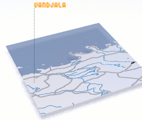
Disclaimer :: Information on this page comes without warranty of any kind |
||
|
Where is Vandjala? Elevation and coordinates ::
Latitude (lat): 59°26'23"N Longitude (lon): 25°4'49"E
Elevation (approx.): 43m (map arrows pan, magnifying glasses zoom) |
||
|
Visiting Vandjala? Hotel/Accommodation ::
Book a hotel in Vandjala Travel Guide ::
Buy a travel guide for Estonia rental cars ::
car rental offers GPS waypoint ::
download a GPX waypoint (PoI) of Vandjala for your GPS receiver
|
||