|
search place name
|
||
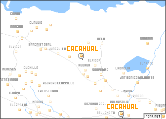
Cacahual (Sancti Spíritus, Cuba)Cacahual is a town in the Sancti Spíritus region of Cuba. An overview map of the region around Cacahual is displayed below.
regional and 3d topo map of Cacahual, Cuba ::
Cacahual airports ::
The nearest airport is AVI - Ciego De Avila Maximo Gomez, located 43.9 km south east of Cacahual.
Other airports nearby include SNU - Santa Clara Abel Santamaria (88.5 km west), CFG - Cienfuegos Jaime Gonzalez (134.9 km west), CMW - Camaguey Ignacio Agramonte Intl (162.1 km south east), Nearby towns ::
Aguada (2.4km south) //
El Rigor (2.8km south east) //
San Agustín (2.9km west) //
Aguada de Pasajeros (3.3km south) //
La Magdalena (3.9km north) //
Chorrerón (4.0km south) //
San Pedro (5.1km south east) //
Nela (5.3km north east) //
Juncalito (5.4km west) //
La Maravilla (6.0km south east) //
Mayajigua (6.6km south east) //
San José del Lago (7.6km south east) //
Agua Santa (8.0km south east) //
Aguada de Carrillo (8.2km south west) //
Centeno (8.2km west) //
La Legua (9.2km south east) //
Joval (10.2km north west) //
Almiquí (10.3km north west) //
La Ensenada (10.9km south west) //
Calienes (10.9km south east) //
[all distances 'as the bird flies' and approximate] 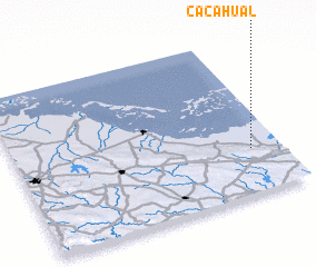 Places with similar names to Cacahual, Cuba ::
Disclaimer :: Information on this page comes without warranty of any kind |
||
|
Where is Cacahual? Elevation and coordinates ::
Latitude (lat): 22°17'3"N Longitude (lon): 79°6'50"W
Elevation (approx.): 15m (map arrows pan, magnifying glasses zoom) |
||
|
Visiting Cacahual? Hotel/Accommodation ::
Book a hotel in Cacahual Travel Guide ::
Buy a travel guide for Cuba rental cars ::
car rental offers GPS waypoint ::
download a GPX waypoint (PoI) of Cacahual for your GPS receiver
|
||