|
search place name
|
||
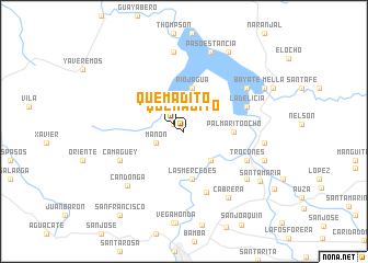
Quemadito (Santiago de Cuba, Cuba)Quemadito is a town in the Santiago de Cuba region of Cuba. An overview map of the region around Quemadito is displayed below.
regional and 3d topo map of Quemadito, Cuba ::
Quemadito airports ::
The nearest airport is SCU - Santiago De Cuba Antonio Maceo Intl, located 42.7 km south of Quemadito.
Other airports nearby include HOG - Holguin Frank Pais Intl (61.0 km north west), BYM - Bayamo Carlos Manuel De Cespedes (66.3 km west), GAO - Guantanamo Mariana Grajales (91.0 km east), MZO - Manzanillo Sierra Maestra (114.8 km west), Nearby towns ::
El Molino (1.2km north west) //
Quemadito (1.2km north west) //
Los Anoncillos (2.1km north) //
Manón (2.9km south west) //
La Cuña de Salvadera (2.9km south west) //
Junco (3.7km north) //
Andrés Vaillant (3.9km south east) //
Rio Jagua (4.5km north) //
Cassasa (4.5km north) //
Menocal (4.5km north) //
Las Mercedes (4.9km south) //
Palmarito Ocho (4.8km east) //
La Teresa (6.5km south) //
La Delicia (6.5km north east) //
Trocones (6.7km south east) //
Camagüey (6.9km south west) //
Bayate (7.4km north east) //
Candonga (7.7km south west) //
Oros (7.7km south east) //
Cabrera (7.9km south east) //
Barrancas (8.2km north) //
Palmarito del Cauto (7.8km east) //
Paso Estancia (8.5km north) //
San Nicolás (8.3km east) //
Santa María (8.8km south east) //
Landíaz (9.2km north east) //
Lindelie (8.9km north east) //
Jagua (8.9km north east) //
San Francisco (10.5km south west) //
[all distances 'as the bird flies' and approximate]  Places with similar names to Quemadito, Cuba ::
Disclaimer :: Information on this page comes without warranty of any kind |
||
|
Where is Quemadito? Elevation and coordinates ::
Latitude (lat): 20°19'37"N Longitude (lon): 75°59'27"W
Elevation (approx.): 131m (map arrows pan, magnifying glasses zoom) |
||
|
Visiting Quemadito? Hotel/Accommodation ::
Book a hotel in Quemadito Travel Guide ::
Buy a travel guide for Cuba rental cars ::
car rental offers GPS waypoint ::
download a GPX waypoint (PoI) of Quemadito for your GPS receiver
|
||