|
search place name
|
||
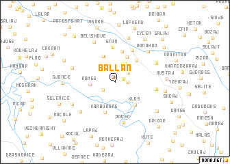
Ballan (Fier, Albania)Ballan is a town in the Fier region of Albania. An overview map of the region around Ballan is displayed below.
regional and 3d topo map of Ballan, Albania ::
Ballan airports ::
The nearest airport is TIA - Tirana Rinas, located 94.7 km north of Ballan.
Other airports nearby include CFU - Kerkyra/corfu Ioannis Kapodistrias Intl (107.9 km south), OHD - Ohrid (110.3 km north east), KSO - Kastoria Aristotelis (133.2 km east), IOA - Ioannina (134.5 km south east), Nearby towns ::
Sinanaj (1.2km north east) //
Hekal (1.5km east) //
Mollaj (1.9km south west) //
Kash (2.2km north east) //
Fejzoltaraj (3.2km north) //
Romës (3.1km west) //
Ballsh (4.3km north) //
(( Drenovë-Fushë )) (4.5km north) //
Drenovë (4.5km north) //
Klos (4.4km south east) //
Usojë (4.4km north east) //
Dukas (5.1km north) //
Karbunarë (5.1km south) //
Stan (5.7km north) //
Lavdan (5.6km north) //
Poçem (6.7km south) //
Greshicë (5.2km east) //
Panahor (6.4km north east) //
Belishovë (7.0km north) //
Kalenjë (6.0km north east) //
Romës (6.4km south west) //
Gorishovë (5.8km north west) //
Lapulec (7.4km north) //
Resulaj (6.4km south west) //
Lamaj (6.3km east) //
Kremenar (7.0km south east) //
Mustaj (6.3km east) //
Çyçen (7.9km north east) //
Gjonçë (6.5km west) //
[all distances 'as the bird flies' and approximate] 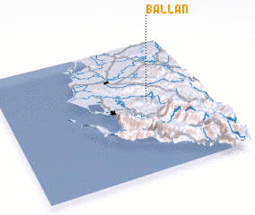 Places with similar names to Ballan, Albania ::
Disclaimer :: Information on this page comes without warranty of any kind |
||
|
Where is Ballan? Elevation and coordinates ::
Latitude (lat): 40°33'44"N Longitude (lon): 19°43'5"E
Elevation (approx.): 281m (map arrows pan, magnifying glasses zoom) |
||
|
Visiting Ballan? Hotel/Accommodation ::
Book a hotel in Ballan Travel Guide ::
Buy a travel guide for Albania rental cars ::
car rental offers GPS waypoint ::
download a GPX waypoint (PoI) of Ballan for your GPS receiver
|
||