|
search place name
|
||
Buzgarë (Elbasan, Albania)Buzgarë is a town in the Elbasan region of Albania. An overview map of the region around Buzgarë is displayed below.
regional and 3d topo map of Buzgarë, Albania ::

Buzgarë airports ::
The nearest airport is OHD - Ohrid, located 26.1 km east of Buzgarë.
Other airports nearby include TIA - Tirana Rinas (67.5 km north west), KSO - Kastoria Aristotelis (104.8 km south east), SKP - Skopje (134.7 km north east), KZI - Kozani Filippos (151.7 km south east), Nearby towns ::
Vehçan (1.7km south) //
Vulçan (2.5km west) //
Kokrevë (3.0km west) //
Xhyrë (3.5km south west) //
Hotolisht (3.9km north west) //
Qukës-Shkumbin (5.0km south) //
Çelçan (3.9km west) //
Qukës-Skënderbe (5.9km south) //
Skroskë (6.3km south east) //
Gurrë (7.7km south) //
Dardhë (5.9km west) //
Dragostunjë (7.8km north west) //
Pishkash (7.8km south east) //
Karkavec (9.0km south east) //
Lipofnik (8.7km south east) //
Librazhd-Katund (10.3km north west) //
Plishtës (10.7km south east) //
[all distances 'as the bird flies' and approximate] 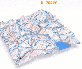 Places with similar names to Buzgarë, Albania ::
// Bou Skour (MA)
// Bou Ousakkour (MA)
// Baskura (ET)
// Bosacker (DE)
// Boschiere (IT)
// Bāsakrah (IQ)
// Bessaker (NO)
// Besiekiery (PL)
// Basquira (BO)
// Beškeri (BA)
Disclaimer :: Information on this page comes without warranty of any kind |
||
|
Where is Buzgarë? Elevation and coordinates ::
Latitude (lat): 41°8'14"N Longitude (lon): 20°26'12"E
Elevation (approx.): 861m (map arrows pan, magnifying glasses zoom) |
||
|
Visiting Buzgarë? Hotel/Accommodation ::
Book a hotel in Buzgarë Travel Guide ::
Buy a travel guide for Albania rental cars ::
car rental offers GPS waypoint ::
download a GPX waypoint (PoI) of Buzgarë for your GPS receiver
|
||