|
search place name
|
||
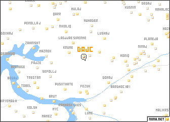
Dajç (Kukës, Albania)Dajç is a town in the Kukës region of Albania. An overview map of the region around Dajç is displayed below.
regional and 3d topo map of Dajç, Albania ::
Dajç airports ::
The nearest airport is PRN - Pristina, located 65.3 km north east of Dajç.
Other airports nearby include SKP - Skopje (100.3 km east), TGD - Podgorica (100.4 km west), TIA - Tirana Rinas (104.2 km south west), OHD - Ohrid (113.8 km south), Nearby towns ::
Mujaj (1.4km north east) //
Cahan (3.1km north east) //
Krumë (3.2km north west) //
Lagjja e Sipërme (4.4km north west) //
Çemët (4.4km east) //
Kishaj (4.7km east) //
Vlahën (6.5km north) //
Lushaj (5.9km north east) //
Fezuk (6.6km south) //
Gjinaj (6.9km south) //
Domaj (6.1km south east) //
(( San Sula )) (7.1km south) //
Vranisht (5.5km west) //
Pusi i Thatë (7.0km south west) //
Nikoliq (7.1km north west) //
Muhadër (7.8km north) //
Sefollj (6.6km south west) //
Mazrek (6.4km west) //
Norgut (9.6km south east) //
Golaj (9.2km north west) //
Bardhoci i Ri (9.0km south east) //
(( Xhah )) (9.5km south east) //
Bardhoc (9.6km south east) //
Dautaj (9.4km north west) //
(( Brut )) (10.3km south west) //
[all distances 'as the bird flies' and approximate]  Places with similar names to Dajç, Albania ::
Disclaimer :: Information on this page comes without warranty of any kind |
||
|
Where is Dajç? Elevation and coordinates ::
Latitude (lat): 42°10'48"N Longitude (lon): 20°26'43"E
Elevation (approx.): 1040m (map arrows pan, magnifying glasses zoom) |
||
|
Visiting Dajç? Hotel/Accommodation ::
Book a hotel in Dajç Travel Guide ::
Buy a travel guide for Albania rental cars ::
car rental offers GPS waypoint ::
download a GPX waypoint (PoI) of Dajç for your GPS receiver
|
||