|
search place name
|
||
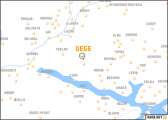
Degë (Kukës, Albania)Degë is a town in the Kukës region of Albania. An overview map of the region around Degë is displayed below.
regional and 3d topo map of Degë, Albania ::
Degë airports ::
The nearest airport is TGD - Podgorica, located 73.0 km west of Degë.
Other airports nearby include PRN - Pristina (81.4 km north east), TIA - Tirana Rinas (101.7 km south), TIV - Tivat (116.8 km west), SKP - Skopje (128.2 km east), Nearby towns ::
Majac (1.0km south) //
Kryelug (1.1km north) //
Tëplan (3.7km west) //
Mashë (4.3km south east) //
Çukë (4.8km south) //
Gjonpapaj (4.4km south east) //
Rushtë (5.4km south east) //
Rexhaj (4.5km east) //
Luzhë (5.8km north west) //
Apripa e Keke (6.2km south west) //
(( Fang )) (5.8km north west) //
(( Dunishë )) (5.8km north west) //
Mëzi (6.8km south) //
Llugaj (7.3km north) //
Rreze-Mali (7.7km north) //
Arst (7.5km south) //
Shëngjergj (7.2km south east) //
Sinanaj (6.3km north east) //
Bujan (7.0km north west) //
Tufaj (6.0km east) //
Demaliaj (6.5km north east) //
Berishë (7.1km south east) //
Vlad (7.1km north east) //
Poravë (7.0km south west) //
Pac (6.6km east) //
(( Bytyç )) (7.0km north east) //
Miliska (8.2km south west) //
Gri (7.7km north west) //
Dojan (8.9km north west) //
[all distances 'as the bird flies' and approximate]  Places with similar names to Degë, Albania ::
Disclaimer :: Information on this page comes without warranty of any kind |
||
|
Where is Degë? Elevation and coordinates ::
Latitude (lat): 42°16'39"N Longitude (lon): 20°7'48"E
Elevation (approx.): 566m (map arrows pan, magnifying glasses zoom) |
||
|
Visiting Degë? Hotel/Accommodation ::
Book a hotel in Degë Travel Guide ::
Buy a travel guide for Albania rental cars ::
car rental offers GPS waypoint ::
download a GPX waypoint (PoI) of Degë for your GPS receiver
|
||