|
search place name
|
||
Divjakë (Fier, Albania)Divjakë is a town in the Fier region of Albania. An overview map of the region around Divjakë is displayed below.
regional and 3d topo map of Divjakë, Albania ::

Divjakë airports ::
The nearest airport is TIA - Tirana Rinas, located 49.1 km north of Divjakë.
Other airports nearby include OHD - Ohrid (103.9 km east), BDS - Brindisi Casale (138.7 km west), LCC - Lecce (145.0 km south west), TGD - Podgorica (153.1 km north), Nearby towns ::
Xeng (2.3km south) //
Shëneprëmte (3.5km north east) //
Mizë (3.9km south) //
Gërmenj i Madh (3.6km east) //
Sulzotaj (4.8km north) //
Bishçukas (4.5km north east) //
Hallvaxhijas (4.3km east) //
Gërmenji i Vogël (4.4km north east) //
(( Kular )) (5.1km north west) //
Bregas (5.1km south east) //
Zharnec (6.3km south) //
Dushku i Madh (5.4km south east) //
Ballaj (6.5km north) //
(( Bashtovë )) (6.4km north west) //
Vilë-Ballaj (6.7km north) //
Grabjan (6.5km south east) //
(( Shelk )) (7.0km north west) //
Kryekuq (8.0km south) //
Çermë Shkumbin (7.3km north east) //
(( Shënkollas )) (6.8km south east) //
Meç (8.8km south) //
(( Plemerë )) (8.4km south east) //
Rreth-Greth (8.9km north west) //
Spolatë (9.9km south east) //
(( Çermë e Vogël )) (9.8km north east) //
Kalush (10.5km north east) //
[all distances 'as the bird flies' and approximate] 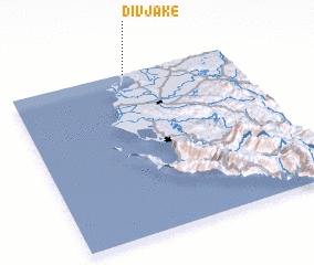
Disclaimer :: Information on this page comes without warranty of any kind |
||
|
Where is Divjakë? Elevation and coordinates ::
Latitude (lat): 40°59'48"N Longitude (lon): 19°31'46"E
(map arrows pan, magnifying glasses zoom) |
||
|
Visiting Divjakë? Hotel/Accommodation ::
Book a hotel in Divjakë Travel Guide ::
Buy a travel guide for Albania rental cars ::
car rental offers GPS waypoint ::
download a GPX waypoint (PoI) of Divjakë for your GPS receiver
|
||