|
search place name
|
||
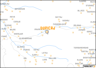
Duricaj (Dibër, Albania)Duricaj is a town in the Dibër region of Albania. An overview map of the region around Duricaj is displayed below.
regional and 3d topo map of Duricaj, Albania ::
Duricaj airports ::
The nearest airport is TIA - Tirana Rinas, located 44.5 km west of Duricaj.
Other airports nearby include OHD - Ohrid (54.7 km south east), SKP - Skopje (125.9 km north east), TGD - Podgorica (126.2 km north west), PRN - Pristina (136.4 km north east), Nearby towns ::
Bulqizë (1.7km west) //
Vajkal-Bulqizë (2.1km north west) //
Dragua-Bulqizë (3.3km north east) //
Fushë-Bulqizë (4.4km north east) //
Koçaj (6.0km north east) //
Shytaj (6.5km north east) //
Dushaj (6.8km north east) //
Kotaj (7.8km south west) //
Letaj (8.3km south) //
Koxheraj (8.5km south) //
Plani i Bardhë (7.1km west) //
Krastë (8.8km south) //
Krastë (8.8km south) //
Staveç (9.4km south west) //
[all distances 'as the bird flies' and approximate]  Places with similar names to Duricaj, Albania ::
// Trokaj (AL)
// Târgu Jiu (RO)
// Tariquejo (ES)
// Torkej (SD)
// Durakju (PK)
// (( Dorakaj )) (AL)
// (( Trocaj )) (AL)
// Turkeije (NL)
// Dragaj (CS)
Disclaimer :: Information on this page comes without warranty of any kind |
||
|
Where is Duricaj? Elevation and coordinates ::
Latitude (lat): 41°29'48"N Longitude (lon): 20°14'29"E
Elevation (approx.): 876m (map arrows pan, magnifying glasses zoom) |
||
|
Visiting Duricaj? Hotel/Accommodation ::
Book a hotel in Duricaj Travel Guide ::
Buy a travel guide for Albania rental cars ::
car rental offers GPS waypoint ::
download a GPX waypoint (PoI) of Duricaj for your GPS receiver
|
||