|
search place name
|
||
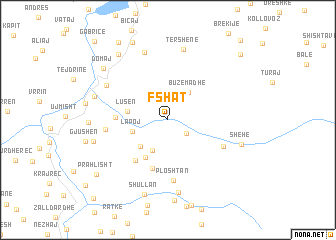
Fshat (Kukës, Albania)Fshat is a town in the Kukës region of Albania. An overview map of the region around Fshat is displayed below.
regional and 3d topo map of Fshat, Albania ::
Fshat airports ::
The nearest airport is TIA - Tirana Rinas, located 81.6 km south west of Fshat.
Other airports nearby include OHD - Ohrid (84.2 km south), PRN - Pristina (88.6 km north east), SKP - Skopje (97.4 km east), TGD - Podgorica (111.1 km north west), Nearby towns ::
Shkinak (2.1km south east) //
Gjegjet (3.6km south) //
Buzëmadhe (3.5km north east) //
Lapoj (3.2km south west) //
Bushtricë (3.7km south west) //
Lusën (3.5km west) //
Matranxh (4.6km south west) //
Vasije (5.6km south) //
Palush (5.3km south west) //
Zall (4.3km west) //
Ploshtan (6.7km south) //
Çajë (5.5km south east) //
Shpat (5.3km west) //
Malqenë (6.5km north west) //
Mëhole (7.8km north) //
Tërshenë (7.9km north) //
Ceren (8.2km south) //
Resk (6.6km north west) //
Shehe (6.7km south east) //
Vilë (6.7km west) //
Shullan (8.6km south) //
Barruç (6.6km west) //
Kolesjan (8.4km north west) //
Domaj (7.8km north west) //
Mustafaj (9.2km north) //
Prahlisht (8.5km south west) //
Osmanaj (9.6km north west) //
Xhaferraj (9.4km north east) //
Topojan (10.7km north east) //
[all distances 'as the bird flies' and approximate]  Places with similar names to Fshat, Albania ::
Disclaimer :: Information on this page comes without warranty of any kind |
||
|
Where is Fshat? Elevation and coordinates ::
Latitude (lat): 41°54'18"N Longitude (lon): 20°26'58"E
Elevation (approx.): 948m (map arrows pan, magnifying glasses zoom) |
||
|
Visiting Fshat? Hotel/Accommodation ::
Book a hotel in Fshat Travel Guide ::
Buy a travel guide for Albania rental cars ::
car rental offers GPS waypoint ::
download a GPX waypoint (PoI) of Fshat for your GPS receiver
|
||