|
search place name
|
||
Himarë (Vlorë, Albania)Himarë is a town in the Vlorë region of Albania. An overview map of the region around Himarë is displayed below.
regional and 3d topo map of Himarë, Albania ::

Himarë airports ::
The nearest airport is CFU - Kerkyra/corfu Ioannis Kapodistrias Intl, located 57.3 km south of Himarë.
Other airports nearby include IOA - Ioannina (102.6 km south east), KSO - Kastoria Aristotelis (136.2 km east), LCC - Lecce (138.1 km west), TIA - Tirana Rinas (145.8 km north), Nearby towns ::
(( Spile )) (1.0km west) //
Një Maj (1.8km north east) //
Sen (1.9km east) //
Kostane (3.3km north) //
Kokor (4.1km north) //
Pilur (4.0km north east) //
Jal (4.0km north west) //
(( Palermo )) (5.9km south east) //
Vuno (6.1km north west) //
Kudhës (6.2km east) //
Ilias (7.8km north west) //
Qeparo (8.2km south east) //
Fushë Brrati (9.8km north east) //
[all distances 'as the bird flies' and approximate] 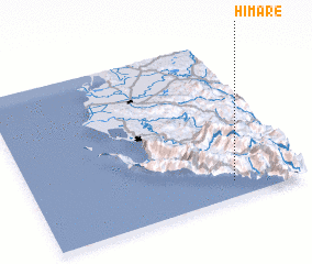 Places with similar names to Himarë, Albania ::
Disclaimer :: Information on this page comes without warranty of any kind |
||
|
Where is Himarë? Elevation and coordinates ::
Latitude (lat): 40°6'6"N Longitude (lon): 19°44'41"E
Elevation (approx.): 3m (map arrows pan, magnifying glasses zoom) |
||
|
Visiting Himarë? Hotel/Accommodation ::
Book a hotel in Himarë Travel Guide ::
Buy a travel guide for Albania rental cars ::
car rental offers GPS waypoint ::
download a GPX waypoint (PoI) of Himarë for your GPS receiver
|
||