|
search place name
|
||
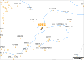
Mreg (Shkodër, Albania)Mreg is a town in the Shkodër region of Albania. An overview map of the region around Mreg is displayed below.
regional and 3d topo map of Mreg, Albania ::
Mreg airports ::
The nearest airport is TGD - Podgorica, located 35.3 km south west of Mreg.
Other airports nearby include TIV - Tivat (74.9 km west), DBV - Dubrovnik (111.1 km west), PRN - Pristina (116.5 km east), TIA - Tirana Rinas (123.4 km south), Nearby towns ::
Javor (1.9km north east) //
Selcë (2.4km south west) //
Vukël (4.6km south east) //
(( Prosica )) (4.7km north west) //
Muriq (5.2km south) //
Kozhnje (7.2km south) //
Gropat e Selcës (6.1km east) //
Kozhnja e Sipërme (8.9km south) //
Nikç (7.6km south east) //
Tamarë (8.1km south west) //
Katsë (9.0km south) //
Vermosh (9.3km north) //
Vermosh (9.2km north east) //
[all distances 'as the bird flies' and approximate]  Places with similar names to Mreg, Albania ::
Disclaimer :: Information on this page comes without warranty of any kind |
||
|
Where is Mreg? Elevation and coordinates ::
Latitude (lat): 42°31'23"N Longitude (lon): 19°37'10"E
Elevation (approx.): 1026m (map arrows pan, magnifying glasses zoom) |
||
|
Visiting Mreg? Hotel/Accommodation ::
Book a hotel in Mreg Travel Guide ::
Buy a travel guide for Albania rental cars ::
car rental offers GPS waypoint ::
download a GPX waypoint (PoI) of Mreg for your GPS receiver
|
||