|
search place name
|
||
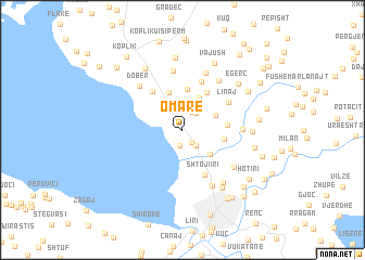
Omarë (Shkodër, Albania)Omarë is a town in the Shkodër region of Albania. An overview map of the region around Omarë is displayed below.
regional and 3d topo map of Omarë, Albania ::
Omarë airports ::
The nearest airport is TGD - Podgorica, located 30.7 km north west of Omarë.
Other airports nearby include TIV - Tivat (69.3 km north west), TIA - Tirana Rinas (83.5 km south), DBV - Dubrovnik (110.6 km north west), PRN - Pristina (136.1 km east), Nearby towns ::
Boriçi i Madh (1.5km south east) //
Grilë (1.7km south) //
Grudë-Fushë (1.9km north) //
Boriçi i Vogël (1.9km south east) //
Gjormi i Poshtëm (2.2km north) //
Grudë-Fushë (2.1km north east) //
Ktosh (2.7km north) //
Gruemirë (2.9km north east) //
Mëshqerrë (3.6km north) //
Gucia e Re (3.3km south east) //
Demiraj (3.9km north) //
Demaj (4.2km north) //
Kullaj (3.3km east) //
Gjorm (4.3km north east) //
Rrash-Kullaj (3.5km east) //
(( Çesme e Koplikut )) (4.5km north west) //
Shtoji i Ri (4.9km south) //
Hysebaj (5.2km north) //
Linaj (4.6km north east) //
Hysaj (4.6km east) //
(( Gruemirë-Çesme )) (6.1km north) //
Lopç (6.1km north) //
Dobër (5.6km north west) //
Kcar (5.8km north east) //
Gruda e Re (5.5km south east) //
Dergjinaj (6.2km south) //
Golem (6.3km south east) //
Golemi i Poshtëm (6.6km south east) //
Rrash i Vorfës (5.4km east) //
[all distances 'as the bird flies' and approximate]  Places with similar names to Omarë, Albania ::
Disclaimer :: Information on this page comes without warranty of any kind |
||
|
Where is Omarë? Elevation and coordinates ::
Latitude (lat): 42°8'46"N Longitude (lon): 19°29'16"E
Elevation (approx.): 39m (map arrows pan, magnifying glasses zoom) |
||
|
Visiting Omarë? Hotel/Accommodation ::
Book a hotel in Omarë Travel Guide ::
Buy a travel guide for Albania rental cars ::
car rental offers GPS waypoint ::
download a GPX waypoint (PoI) of Omarë for your GPS receiver
|
||