|
search place name
|
||
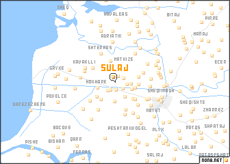
Sulaj (Fier, Albania)Sulaj is a town in the Fier region of Albania. An overview map of the region around Sulaj is displayed below.
regional and 3d topo map of Sulaj, Albania ::
Sulaj airports ::
The nearest airport is TIA - Tirana Rinas, located 75.2 km north of Sulaj.
Other airports nearby include OHD - Ohrid (114.2 km north east), LCC - Lecce (129.7 km south west), BDS - Brindisi Casale (132.1 km west), CFU - Kerkyra/corfu Ioannis Kapodistrias Intl (133.0 km south), Nearby towns ::
Bufaj (1.1km north) //
Muçaj (1.2km south) //
Kraksniq (1.4km south west) //
Hebej (1.2km north east) //
Stojk (1.4km south east) //
Dërmënas (1.7km south west) //
Makaj (1.4km east) //
Hamil (2.0km east) //
Çlirim (2.6km south east) //
Toskallar (2.3km south east) //
Hoxharë (2.4km west) //
Radostinë (3.1km south) //
Matkizë (3.1km north east) //
(( Baltëzë-Kotë )) (2.6km east) //
Seman i Ri (3.5km north) //
(( Sinanbejlli )) (3.3km south west) //
Havaleas (3.2km south west) //
Baltëz (2.9km east) //
Muçaj (3.0km east) //
Afrimi i Ri (3.5km south east) //
(( Murtajas )) (3.7km south east) //
Seman (3.7km north west) //
Vadhizë (4.6km south) //
Grem (3.8km north east) //
Pojan (4.4km south west) //
Afrim (4.6km south east) //
Kryegjatë (4.9km south west) //
(( Shterpas )) (5.0km north) //
Gjokalli (4.2km north west) //
[all distances 'as the bird flies' and approximate]  Places with similar names to Sulaj, Albania ::
Disclaimer :: Information on this page comes without warranty of any kind |
||
|
Where is Sulaj? Elevation and coordinates ::
Latitude (lat): 40°45'29"N Longitude (lon): 19°30'16"E
Elevation (approx.): 2m (map arrows pan, magnifying glasses zoom) |
||
|
Visiting Sulaj? Hotel/Accommodation ::
Book a hotel in Sulaj Travel Guide ::
Buy a travel guide for Albania rental cars ::
car rental offers GPS waypoint ::
download a GPX waypoint (PoI) of Sulaj for your GPS receiver
|
||