|
search place name
|
||
Thanë (Elbasan, Albania)Thanë is a town in the Elbasan region of Albania. An overview map of the region around Thanë is displayed below.
regional and 3d topo map of Thanë, Albania ::

Thanë airports ::
The nearest airport is TIA - Tirana Rinas, located 48.6 km north west of Thanë.
Other airports nearby include OHD - Ohrid (63.3 km east), KSO - Kastoria Aristotelis (125.7 km south east), CFU - Kerkyra/corfu Ioannis Kapodistrias Intl (159.6 km south), TGD - Podgorica (159.9 km north west), Nearby towns ::
Gjergjan (1.6km north east) //
Malasejë (2.0km south) //
Muriqan (1.9km north west) //
Gjonëm (2.4km east) //
Shtërmen (3.2km south) //
Jagodinë (3.5km north) //
Cërrik (3.1km west) //
Bujaras (3.4km east) //
Gostimë (4.7km south) //
Shirgjan (3.8km north east) //
Kodër-Bujaras (4.4km south east) //
Vidhas (5.0km north west) //
(( Shushicë)) (4.5km south west) //
(( Lykin )) (5.4km north) //
Kuqan (4.7km north east) //
Bujqës (5.3km north east) //
Papër (4.6km west) //
Pozhak (6.1km south) //
Bathës (5.4km north east) //
Fikas (6.9km north) //
(( Valas-Cërrik )) (5.4km west) //
Valas (5.5km west) //
Blatë (6.6km south west) //
Mjekës (6.1km north east) //
(( Thanë )) (5.7km south west) //
Blatë (6.5km south west) //
Katundi i Ri (7.1km north) //
Tregan (5.7km east) //
Floq (7.3km south) //
[all distances 'as the bird flies' and approximate] 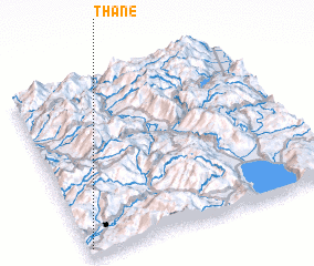 Places with similar names to Thanë, Albania ::
Disclaimer :: Information on this page comes without warranty of any kind |
||
|
Where is Thanë? Elevation and coordinates ::
Latitude (lat): 41°2'13"N Longitude (lon): 20°0'45"E
Elevation (approx.): 94m (map arrows pan, magnifying glasses zoom) |
||
|
Visiting Thanë? Hotel/Accommodation ::
Book a hotel in Thanë Travel Guide ::
Buy a travel guide for Albania rental cars ::
car rental offers GPS waypoint ::
download a GPX waypoint (PoI) of Thanë for your GPS receiver
|
||