|
search place name
|
||
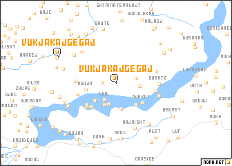
Vukjakaj-Gegaj (Shkodër, Albania)Vukjakaj-Gegaj is a town in the Shkodër region of Albania. An overview map of the region around Vukjakaj-Gegaj is displayed below.
regional and 3d topo map of Vukjakaj-Gegaj, Albania ::
Vukjakaj-Gegaj airports ::
The nearest airport is TGD - Podgorica, located 50.5 km north west of Vukjakaj-Gegaj.
Other airports nearby include TIA - Tirana Rinas (76.3 km south), TIV - Tivat (91.6 km west), PRN - Pristina (117.8 km north east), OHD - Ohrid (131.3 km south east), Nearby towns ::
Krua i Madh (1.7km west) //
Lum (3.0km south west) //
Benë (2.5km east) //
Pecaj (3.5km south) //
Palaj-Gushtë (2.9km east) //
Lekaj (3.7km south) //
Shllinë (4.2km south) //
Mahallʼ e Vnit (3.8km south west) //
Slym (4.2km south east) //
Mgajn (3.7km west) //
Mjekut (4.4km south east) //
Markolaj (4.8km south west) //
Ngropuk (4.9km south west) //
Kunorë (4.7km north west) //
Karmë (5.1km south west) //
Malas (4.9km west) //
Koman (4.9km east) //
Barcollë (4.9km west) //
Qerret (5.2km east) //
Gushtë (5.1km east) //
Palaj-Gushtë (5.5km east) //
Ndërmollës (6.5km north west) //
Majnisht (7.6km south) //
Gjols (6.8km north west) //
Dush (7.6km south east) //
Ukaj (6.8km south west) //
Mllojë (6.9km south west) //
Sbuc (6.8km west) //
Mashnë (8.9km south) //
[all distances 'as the bird flies' and approximate] 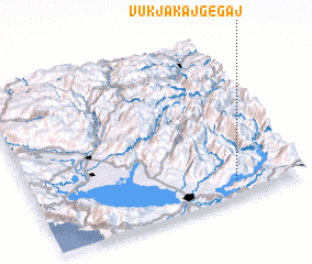 Places with similar names to Vukjakaj-Gegaj, Albania ::
// Vukjakaj-Gegaj (AL)
Disclaimer :: Information on this page comes without warranty of any kind |
||
|
Where is Vukjakaj-Gegaj? Elevation and coordinates ::
Latitude (lat): 42°6'4"N Longitude (lon): 19°45'18"E
Elevation (approx.): 603m (map arrows pan, magnifying glasses zoom) |
||
|
Visiting Vukjakaj-Gegaj? Hotel/Accommodation ::
Book a hotel in Vukjakaj-Gegaj Travel Guide ::
Buy a travel guide for Albania rental cars ::
car rental offers GPS waypoint ::
download a GPX waypoint (PoI) of Vukjakaj-Gegaj for your GPS receiver
|
||