|
search place name
|
||
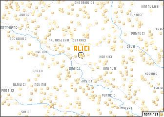
Alići (Federacija Bosne i Hercegovine, Bosnia and Herzegovina)Alići is a town in the Federacija Bosne i Hercegovine region of Bosnia and Herzegovina. An overview map of the region around Alići is displayed below.
regional and 3d topo map of Alići, Bosnia and Herzegovina ::
Alići airports ::
The nearest airport is SJJ - Sarajevo, located 89.9 km south of Alići.
Other airports nearby include OSI - Osijek (97.3 km north), BEG - Beograd (151.0 km east), OMO - Mostar (156.8 km south), Nearby towns ::
Miričina (0.4km north west) //
Suljići (0.7km north) //
Nukići (1.3km north east) //
Durakovići (1.2km north west) //
Berkovica (1.7km south east) //
Omerbašići (2.1km north west) //
Brdo (2.4km north) //
Budimovi (1.9km west) //
Rašljeva (2.7km north) //
Gnojnica (2.4km south east) //
Mahala (3.1km north) //
Oštraci (3.2km north) //
Basići (2.5km west) //
Polje (3.0km south east) //
Kulići (3.2km north west) //
Mehići (3.4km north) //
Kojići (3.4km south) //
Turkovići (3.2km north west) //
Hanići (2.9km east) //
Loparići (3.2km south east) //
Bisići (3.0km west) //
Mitrovići (3.6km south west) //
Marjanovići (3.8km south west) //
Bajići (3.5km north west) //
Panići (3.5km south west) //
Gornja Mahala (4.1km north east) //
Radići (4.7km south) //
Lužani (4.5km south west) //
Lužani (3.7km south west) //
[all distances 'as the bird flies' and approximate]  Places with similar names to Alići, Bosnia and Herzegovina ::
Disclaimer :: Information on this page comes without warranty of any kind |
||
|
Where is Alići? Elevation and coordinates ::
Latitude (lat): 44°37'53"N Longitude (lon): 18°25'16"E
Elevation (approx.): 230m (map arrows pan, magnifying glasses zoom) |
||
|
Visiting Alići? Hotel/Accommodation ::
Book a hotel in Alići Travel Guide ::
rental cars ::
car rental offers GPS waypoint ::
download a GPX waypoint (PoI) of Alići for your GPS receiver
|
||