|
search place name
|
||
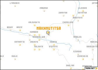
Makhmutitsa (Bulgaria)Makhmutitsa is a town in Bulgaria. An overview map of the region around Makhmutitsa is displayed below.
regional and 3d topo map of Makhmutitsa, Bulgaria ::
Makhmutitsa airports ::
The nearest airport is PDV - Plovdiv, located 45.2 km north east of Makhmutitsa.
Other airports nearby include KVA - Kavala Megas Alexandros Intl (87.4 km south), AXD - Alexandroupolis Dimokritos (146.2 km south east), SOF - Sofia (149.0 km north west), GOZ - Gorna Orechovica Gorna Oryahovitsa (184.7 km north east), Nearby towns ::
Kukuvitsa (0.0km north) //
Dzhurkalitsa (2.8km west) //
Vodata (4.0km south) //
Shiroka Lŭka (3.3km south west) //
Stikŭl (3.3km south west) //
Solomon (3.3km south west) //
Vŭrbovo (4.2km west) //
Stoykite (5.7km south) //
Grashtitsa (5.7km south) //
Kalevishte (5.6km north west) //
Magardzhitsa (5.6km south west) //
Zaevete (5.6km south west) //
Solishta (6.2km south west) //
Slivovo (5.5km west) //
Gorski Dol (5.8km west) //
Gela (6.9km south west) //
Chepelare (6.7km north east) //
Zornitsa (8.5km north east) //
[all distances 'as the bird flies' and approximate]  Places with similar names to Makhmutitsa, Bulgaria :: Disclaimer :: Information on this page comes without warranty of any kind |
||
|
Where is Makhmutitsa? Elevation and coordinates ::
Latitude (lat): 41°42'0"N Longitude (lon): 24°37'0"E
Elevation (approx.): 1531m (map arrows pan, magnifying glasses zoom) |
||
|
Visiting Makhmutitsa? Hotel/Accommodation ::
Book a hotel in Makhmutitsa Travel Guide ::
Buy a travel guide for Bulgaria rental cars ::
car rental offers GPS waypoint ::
download a GPX waypoint (PoI) of Makhmutitsa for your GPS receiver
|
||