|
search place name
|
||
Pēterupe (Rīgas Rajons, Latvia)Pēterupe is a town in the Rīgas Rajons region of Latvia. An overview map of the region around Pēterupe is displayed below.
regional and 3d topo map of Pēterupe, Latvia ::
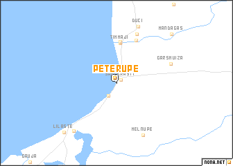
Nearby towns ::
Saulkrasti (0.7km north east) //
Pabaži (2.2km south) //
(( Timmaji )) (6.5km north) //
Zvejniekciems (6.7km north) //
VEF-Skulte (7.1km north) //
Skulte (8.1km north) //
Gāršmuiža (5.6km north east) //
(( Melnupe )) (8.7km south) //
Ezerzviedri (8.5km south west) //
Lilaste (9.1km south west) //
Mandagas (9.2km north east) //
[all distances 'as the bird flies' and approximate]  Places with similar names to Pēterupe, Latvia ::
// Pudripp (DE)
// Padurupiai (LT)
// Pedro Pi (CU)
// Paddiruppu (LK)
// Patuarepa (PF)
// Padaurip (ID)
// Paderup (DK)
// Påtarp (SE)
// Paturapi (BO)
Disclaimer :: Information on this page comes without warranty of any kind |
||
|
Where is Pēterupe? Elevation and coordinates ::
Latitude (lat): 57°15'31"N Longitude (lon): 24°24'43"E
Elevation (approx.): 13m (map arrows pan, magnifying glasses zoom) |
||
|
Visiting Pēterupe? Hotel/Accommodation ::
Book a hotel in Pēterupe Travel Guide ::
Buy a travel guide for Latvia rental cars ::
car rental offers GPS waypoint ::
download a GPX waypoint (PoI) of Pēterupe for your GPS receiver
|
||